OT: Potential Winter Storm on 3/7-8
- Thread starter RU848789
- Start date
You are using an out of date browser. It may not display this or other websites correctly.
You should upgrade or use an alternative browser.
You should upgrade or use an alternative browser.
A bit dramatic no?Seems like every storm we get layely has major bust potential...as Numbers said while the euro still delivered a wallop it continues to tick west..as other models had been. This is no sure thing..the next 2 model run suites will be the most important runs of our lives

C'mon Murphy, call the SOE.
Hm, it worked.
C'mon Murphy, double Rutgers' funding.

So soft. Half the State may not have any measurable snow. Christie used to do the same thing.Hm, it worked.
C'mon Murphy, double Rutgers' funding.
So soft. Half the State may not have any measurable snow. Christie used to do the same thing.
This scenario actually creates more problems than it solves, because schools will close peremptorily, but employers will still expect everyone so show up for work if the storm fizzles.
E-mail from my son's high school:This scenario actually creates more problems than it solves, because schools will close peremptorily, but employers will still expect everyone so show up for work if the storm fizzles.
"[FONT=Verdana, Arial, Helvetica, sans-serif]We are watching the weather forecast for tomorrow closely. It looks like we could have an early closing. Early closing procedures are found in the Student Handbook on page 4. An early closing is a District decision. If the Superintendent decides to close District schools early:
1. The decisions will be made by 9:00 AM.
2. The early closing announcement will be communicated through an automated call from the District, the school and District websites, www.cancellations.com, News 12 New Jersey and the following radio stations: WJLK FM - 94.3, WKXW FM - 101.5 . The school closing will be announced as Monmouth County Vocational School District.
Note: Please do not call the school.
3. Students will be released by noon and lunch will not be served.
I encourage parents whose students drive to have their students take the bus tomorrow if possible.
If your student drives and wants to take a passenger home from school, or your student wants to go home with a student who drives, we must have written permission on file, or receive both written and verbal permission from the parents of the driver and the passenger. If you anticipate this situation tomorrow, please send a note or email (to @.org) and make the phone call early. Once an early dismissal is announced the school office gets very busy dealing with busses and bus companies.
Thanks"[/FONT]

Rutgers just announced that it will be closed 8am tomorrow to 5am Thursday


Huge cutback south of 95 on Mt Holly snow map
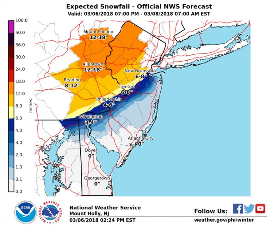
But increase NW of it. Don’t forget a lot of us live there
Huge cutback south of 95 on Mt Holly snow map
here is the new 18z NAM Kuchera...sort of matches up although Mt Holly is a bit high with the totals but shows the gradient with this storm

March 6, 2018, Weather Event Campus Communication
In response to adverse weather conditions, President Barchi has declared a Weather Emergency Closure for Rutgers University as follows:
University Offices Closed
Campus - Commencing - Ending
Wednesday March 7, 2018 at 8:00 am
Thursday March 8, 2018 at 5:00 am
Camden
New Brunswick
Newark
RBHS - Camden
RBHS – New Brunswick
Cancer Institute of New Jersey (CINJ) will be open
RBHS - Newark
Cancer Institute of New Jersey (CINJ) will be open
University Classes Cancelled
Campus - Commencing - Classes Resume
Camden
New Brunswick
RBHS New Brunswick
Newark
RBHS Newark
RBHS Camden
Wednesday March 7, 2018 at 8:00 am
Thursday March 8, 2018: First period at your respective campus.
Check Rutgers.edu for updates.
In response to adverse weather conditions, President Barchi has declared a Weather Emergency Closure for Rutgers University as follows:
University Offices Closed
Campus - Commencing - Ending
Wednesday March 7, 2018 at 8:00 am
Thursday March 8, 2018 at 5:00 am
Camden
New Brunswick
Newark
RBHS - Camden
RBHS – New Brunswick
Cancer Institute of New Jersey (CINJ) will be open
RBHS - Newark
Cancer Institute of New Jersey (CINJ) will be open
University Classes Cancelled
Campus - Commencing - Classes Resume
Camden
New Brunswick
RBHS New Brunswick
Newark
RBHS Newark
RBHS Camden
Wednesday March 7, 2018 at 8:00 am
Thursday March 8, 2018: First period at your respective campus.
Check Rutgers.edu for updates.
A
anon_0k9zlfz6lz9oy
Guest
sooo how much snow is paramus going to get? around zero? How about hoboken? zero as well?Huge cutback south of 95 on Mt Holly snow map
You're looking at a map only showing the Philly office's reportingsooo how much snow is paramus going to get? around zero? How about hoboken? zero as well?
A
anon_0k9zlfz6lz9oy
Guest
I run a private school in Bergen County and deciding whether or not to have class tomorrow.You're looking at a map only showing the Philly office's reporting
I'd post the NYC area map but they haven't updated since 4:24 AM and Numbers doesn't like it when I post old stuff in his threads, even if newer stuff isn't available.
(but here it is if you want to see: https://www.weather.gov/okx/winter)
(but here it is if you want to see: https://www.weather.gov/okx/winter)
I'd post the NYC area map but they haven't updated since 4:24 AM and Numbers doesn't like it when I post old stuff in his threads, even if newer stuff isn't available.
(but here it is if you want to see: https://www.weather.gov/okx/winter)
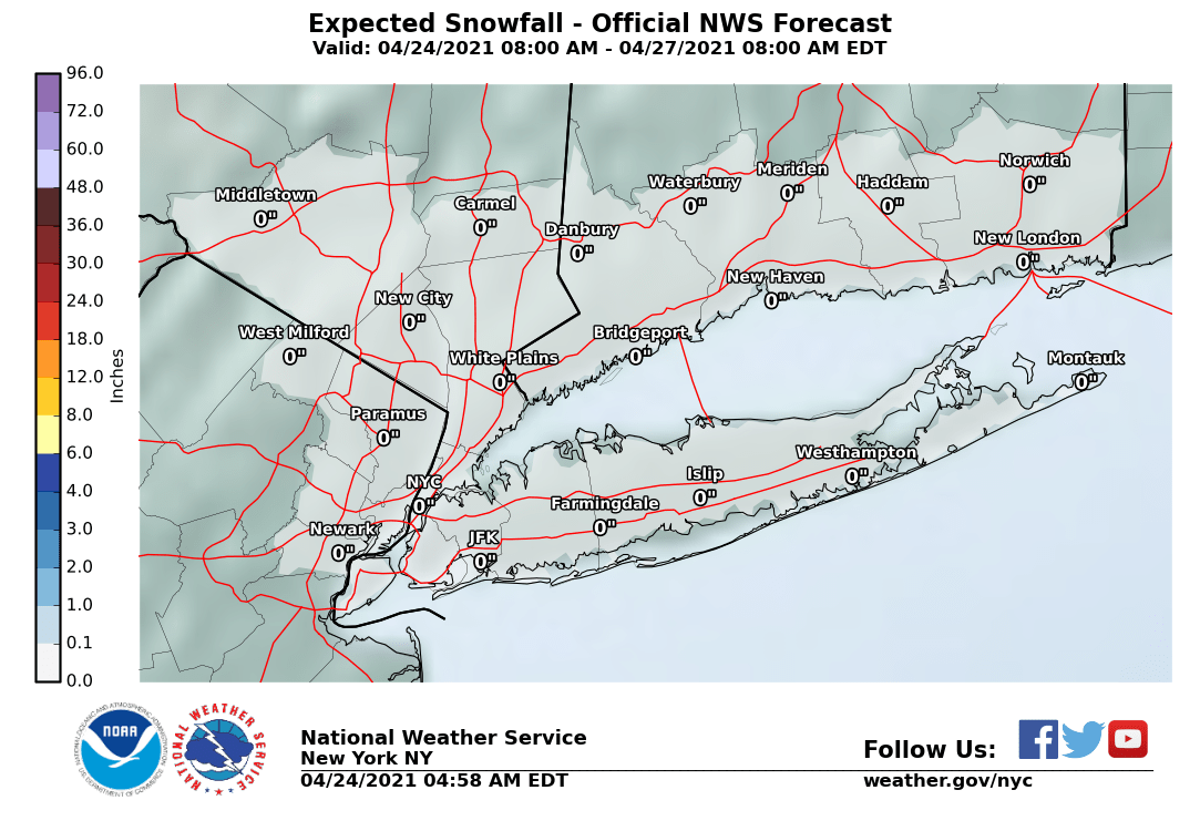
I run a private school in Bergen County and deciding whether or not to have class tomorrow.
You run a school and you don't know how to read a map?

sooo how much snow is paramus going to get? around zero? How about hoboken? zero as well?
https://www.weather.gov/images/okx/winter/StormTotalSnowWeb1.png
Thats 4:24am map
So is that. 4:24AM is the latest map from Upton.
For those of us in eastern monmouth county...

So is that. 4:24AM is the latest map from Upton.
Says 3:46pm for me
I see they have built up the dunes to protect from surge.For those of us in eastern monmouth county...
You run a school and you don't know how to read a map?
Thank you.
The 12Z Euro is a great run, still, for 95, but the precip axis has moved NW about 25-30 miles and surface temps at the height of the storm are 1-2F warmer for 95 and the coast, so areas towards the NJ coast and on eastern LI do much worse for this run vs. 00Z and 95 is all snow (10-16" verbatim), but is very close to rain. I can see maps but can't post them, but it's clear from comparing the last two runs. Any further move NW and the 95 corridor from Phiilly to NYC will be in trouble.
Typical very close call for 95 - many pros say that snowstorms (especially the rain/snow line) for this area are the hardest to forecast anywhere outside of mountainous areas, which are just impossible, with so many elevation changes. But usually, nobody cares about mountainous areas, whereas tens of millions live from DC to Boston. So, yeah, easy forecast. Gun to my head, I don't think the NWS changes the forecast too much, as they're already pretty conservative for the 95 corridor (5-10"), but we might not know the outcome on this one until the event is underway.
One warning: tomorrow morning won't be a big deal, as there will be light snow and maybe rain for 95/coast and the precip doesn't get heavy until the late morning through the late evening. However, where this ends up being all snow, it's going to come down at 1-2" per hour in the afternoon/evening, such that the pm commute could be a nightmare, as heavy snow will accumulate even on major highways and a lot of heavy wet snow will very likely stick to trees (and not blow off easily) leading to downed trees and power outages.
NWS in Philly and NYC generally maintained all of their warnings (pink counties) and converted the areas with watches, e.g., Monmouth and the NJ counties along the Delaware south of Mercer (counties in blue), to advisories for 1-3" and potential for 5". However for the NWS-Philly, in general for the I-95 counties under warnings (see map below), like Middlesex, Mercer and the PA counties along 95 south of Trenton, they've reduced snowfall forecasts to 5-8", due to concerns over mixing with rain, although they do say there could be lollipops up to 11" in NW parts of these counties or at elevation. For the next tier to the NW, they're going with 10-14" and for Sussex/Poconos, they're going with 12-16".
The NWS in NYC also lowered snowfall amounts for warned counties a bit, for the same reason of concerns over mixing with rain. They have 4-8" for NYC/LI, 7-12" for adjacent NJ up to Essex/eastern Bergen and 10-16" for Passaic, western Bergen, the Hudson Valley and most of CT. Maps aren't up yet but should be soon.
Edit: NWS maps finally out. For the NWS-Philly map, maybe the steepest gradient I've ever seen, from NW to SE: 8" in NB to 3" in Freehold, over a distance of just 20 miles! How the hell can that forecast be right? Hint: it won't be, but I don't know which way it'll be wrong and nobody else does either. The suspense makes it fun for me and frustrating at the same time. For the NWS NYC map, there's a significant decrease for LI, but only slight decreases for NYC. And for both offices, snowfall amounts were increased 20+ miles NW of 95 from Philly to Newark and north of about the GWB in NY.


Last edited:
For those of us in eastern monmouth county...
Two weeks ago people were sitting on the beach in 70+ degree weather.
RGEM which had been a huge hit earlier looks less so now...a bit west as well and warmer....its still great for north jersey spitting out nice amounts but less so as you get into central jersey...maybe 4-8 and not much south of Trenton..that cut off line is creeping ever so close.


Two weeks ago people were sitting on the beach in 70+ degree weather.
Last snowstorm I saw this outside my window

I laughed at this and liked it. My class is scheduled to meet at 6 p.m. on Wednesday. I was going to make my decision in the late morning or early afternoon, based on what was happening and what was forecast. But President Barchi has decided I can sleep in. Now my only problem is scheduling the make-up class, which is never easy for an evening class.
Kuchera for 18z GFS., did move east..wtf...and was wetter but not really more snow,...weenies saying that its the temps aloft that make this run better than the 12z

Last edited:
A
anon_0k9zlfz6lz9oy
Guest
Theres like 40 maps wise guy.You run a school and you don't know how to read a map?
Kuchera for 18z GFS., did move east..wtf...and was wetter but not really more snow,...weenies saying that its the temps aloft that make this run better than the 12z
I don’t think you can take this model seriously at this point.
In a storm where those mesoscale bands will be super important to accumulations I don’t think the GFS is capabale of picking up that moisture
Precip intensity won't be that great in our area at midnight, but it will be by mid/late morning, so leaving early works. From midnight to 4 am, you're likely to encounter some accumulating snow on 78 (not a lot but visibility could be cut down) out to Harrisburg and 81 just S of there, whereas, there won't be any accumulating snow in NJ/DE/DC (more likely light snow or rain), so I'd take 95.Im driving to Tennessee from North Jersey around midnight (yes I know). Will I beat out the storm taking 78 W to 81S? OR should I play it safe and take I95 to 81?
Latest
-
01
 The Knight Report
Early Recruit Visitor list for Rutgers Football versus Indiana
The Knight Report
Early Recruit Visitor list for Rutgers Football versus Indiana
-
02
 On3 Football
College Football Hot Seat: USA Today identifies coaches facing mounting pressure
On3 Football
College Football Hot Seat: USA Today identifies coaches facing mounting pressure
-
03
 The Knight Report Football
ESPN FPI projects Rutgers Football's 2026 schedule - Week Four
The Knight Report Football
ESPN FPI projects Rutgers Football's 2026 schedule - Week Four
-
04
 The Knight Report
Rutgers vs Indiana odds: Point spread released on Scarlet Knights, Hoosiers
The Knight Report
Rutgers vs Indiana odds: Point spread released on Scarlet Knights, Hoosiers
-
05
 The Knight Report Football
Every throw from Rutgers Football QB Dylan Lonergan versus Howard
The Knight Report Football
Every throw from Rutgers Football QB Dylan Lonergan versus Howard