OT: Potential Winter Storm on 3/7-8
- Thread starter RU848789
- Start date
You are using an out of date browser. It may not display this or other websites correctly.
You should upgrade or use an alternative browser.
You should upgrade or use an alternative browser.
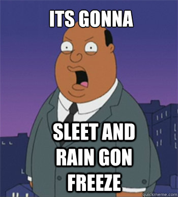


Back in the 70's we didn't have all this media. We had 2 4 7 9 11 21 for news. WCTC WBRW for on the radio. I remember maybe 1 day ahead you would hear of a storm approaching. And some days you just woke up and looked out the window and it was snowing.
we had that noaa weather small square box with the antenna and had to put tinfoil on it to make sure we got reception...did anyone else have won of those
Same here - that and KYW 1060 in Philly, which had the "new" AccuWeather guys on staff making their forecasts, who were ahead of their time and were significantly better, at the time than the folks on any other TV/radio stations (Jim O'Brien the weather guy - not a met, but a bright guy - gave their forecasts on Channel 6 in Philly). In addition to keeping weather records as a kid, I also used to log what KYW 1060 predicted vs. what occurred.
Herb Clarke, Linda Giannello, and Jim O Brien
Sounds like something Bac did back then. Probably was doing his own forcast under the blanket at night.
I had the chalk board with the forecast. I would make up my own weather world with my own 7 day forecast in an alternate world
I'm pretty sure that's NOT what he was doing under the blanket back then.
wait a minute

anyone remember that show AM Weather....i guess precursor to The Weather Channel
Kuchera 0z NAM

10-1 based ratio nam for those who prefer

And the high res 3 km NAM is even more impressive. The NAM often overdoes precip, but some other models are also showing 1-2" of liquid equivalent (10-20" of snow, if all snow), so it's not that much of an outlier. If the snowy models verify, this will become a historic (top 10-20) snowstorm. Stay tuned.

Back in the 70's we didn't have all this media. We had 2 4 7 9 11 21 for news. WCTC WBRW for on the radio. I remember maybe 1 day ahead you would hear of a storm approaching. And some days you just woke up and looked out the window and it was snowing.
more often than that we woke up and the sun was out
I remember one of the Anchors asked Jim Obrien one time how much snow he was expecting.
His answer: "Belly high to a tall dog."
Pretty sure he died in a skydiving accident.
I'll always remember "Belly high to a tall dog." LOL
Yep, that one and "That rain's gonna come down real hard, like a firehose on a flat rock." And the billowy white or grey clouds labelled good guys and bad guys on the weather map. Folksy, but very articulate and a gem of a guy, who died as a hero, helping another skydiver to open his failed chute, saving his life, and then seconds later dying, when his backup chute opened too late.

Yes it will, but just not as much - unless the storm shifts east some and you get over a foot.Not at the shore.
Yep, that one and "That rain's gonna come down real hard, like a firehose on a flat rock." And the billowy white or grey clouds labelled good guys and bad guys on the weather map. Folksy, but very articulate and a gem of a guy, who died as a hero, helping another skydiver to open his failed chute, saving his life, and then seconds later dying, when his backup chute opened too late.
the maps graphics and drawings were always the best.......HUMIDITY....SOUP
Any snow in November or March can just go choke on a pickle.
Blizzard of 96
Most impressive snowstorm I've ever seen. Somewhere between 28 and 32" in our backyard - very hard to measure with all the drifts, some up to 6-7 feet. Shoveled a flatter section of our roof onto the ground, as I was concerned it might collapse, so that we had 5-6 feet of snow on the ground. Then somehow convinced my wife that it would be ok if I jumped off the roof into that snow with our then almost 3 year old son (roof is only about 10 feet above ground). Our son loved it and we then must've done that 20 times. Did the same in Feb 2003 when he was older.

Bob Harris with a real weather map:
Always came across as the “grown up” when it came to TV weather guys.
that is #2 for me. I prefer Feb 83
also on this coming event, I remember a similar event last March..were they not calling for a foot and models were bonkers and after 4-6 inches it turned to sleet for some of us....could this turn into a sleetfest too..before you say its different, its not like they predicted it was going to happen with that storm..edit....after reading through the thread there appeared to be some models that were cutting back on qpf and indication that a mix or rain could factor in very close to the event
also on this coming event, I remember a similar event last March..were they not calling for a foot and models were bonkers and after 4-6 inches it turned to sleet for some of us....could this turn into a sleetfest too..before you say its different, its not like they predicted it was going to happen with that storm..edit....after reading through the thread there appeared to be some models that were cutting back on qpf and indication that a mix or rain could factor in very close to the event
Last edited:
remember last March they predicted 18-24 inches for alot of the area and that did not happen....careful....although they seemed to hug the Euro on that one
https://rutgers.forums.rivals.com/t...ather-thread-this-is-the-b1g-1.120752/page-20
https://rutgers.forums.rivals.com/t...ather-thread-this-is-the-b1g-1.120752/page-20

Last year's 3/14 event was looking like 12-18" of snow for I-95 (with even more NW of there) and even towards the coast, but some models were showing sleet mixing in and that got more pronounced as the event neared and then actually verified for most folks south of 80. Everyone from 95 and NW still got the same amount of frozen precip as forecast, but at least half to 2/3 of it fell as sleet. Not nearly as pretty, but just as impactful.that is #2 for me. I prefer Feb 83
also on this coming event, I remember a similar event last March..were they not calling for a foot and models were bonkers and after 4-6 inches it turned to sleet for some of us....could this turn into a sleetfest too..before you say its different, its not like they predicted it was going to happen with that storm..edit....after reading through the thread there appeared to be some models that were cutting back on qpf and indication that a mix or rain could factor in very close to the event
As a snow lover, I was only slightly disappointed, as snow and sleet are way better than snow and rain. But yes, this storm has significant risk of rain all the way up to at least I-95, so while most of the models are showing 8-16" (or more) for the 95 corridor, not all are and it wouldn't take a big shift to make that 4-8" with a bunch of rain; not seeing sleet being predicted like last year and don't see it on the "soundings" (column profile), which shows, for areas with less snow like Monmouth/Ocean, surface temps well above 32F, but below 32F everywhere above that, which indicates snow or rain, not sleet.
Last edited:
Well, the UK
Even better consensus on a major to possibly historic (at least for March, which has only had 5 snowstorms of 12" or more in NYC) snowstorm along/near I-95 from Trenton to NYC and NW of there tonight. Every major global model (and two main mesoscale models) shows at least 8-12" of snow (using a 10:1 snow to liquid ratio, which might be a bit high) from Trenton to NYC, with most models showing 12-18" (with a little less towards Philly along 95); the one exception to this is the GFS, which shows 4-8" from Trenton to NB and 8-12" from NB to NYC. And for areas just a bit NW of 95 out to 75-100 miles or so NW of 95, it's looking like 12-18" is becoming quite likely - and 18-24" snowfalls are on the table for much of the region, as per a couple of models showing more precip.
However, the gradient from 95 SE to the coast is pretty steep, with the immediate coast getting more like 2-4/4-8", with substantial amounts of rain - model soundings are not showing a sleet signature (warm air aloft/below 32F for the last 1000 feet to the surface) or a freezing rain signature (warm air aloft and below 32F just at the surface), but a rain signature with the column being below 32F until the last 300-500 feet above the surface being above 32F, melting the snow to rain.
It would only take a track shift of 25-50 miles NW of the current track to turn the I-95 accumulations into the Dover, DE to Toms River accumulations of maybe 2-6". Similarly a shift of 25-50 miles SE of the current track would turn the Dover to Toms River accumulations into 8-12/12-18" amounts, depending on the model. And track shifts of that magnitude are clearly possible 30 hours before the start of an event, although I wouldn't consider it "likely" (there's a reason why major busts like Jan 15 and March 01 are remembered so well - 50 mile shifts very late in the game are unusual).
Since it's kind of fun guessing what the NWS will do and I've gotten to be ok at it, I fully expect to see winter storm warnings at 4 am for all the counties that currently have watches (along 95 down to Wilmington and from Mercer over to Monmouth and everything north of 195 and NW of I-95) and perhaps winter storm watches for Ocean and the rest of SE NJ. And it's possible we see blizzard warnings sometime tomorrow for locations expected to get heavy snow and winds, like NYC, LI and maybe Middlesex and Monmouth (I think they'll want to see the 12Z runs tomorrow afternoon first to be sure).
Major snowstorm coming, folks. Pretty decent guess on what the NWS-Philly would do, as they've now issued watches for 3-6", in general, but up to 12" in spots (the NW sections of this swath, like Metuchen and NB), for all of the I-95 corridor counties from Middlesex down through Philly and Wilmington, including all the PA/NJ counties on each side of the Delaware, as well as Monmouth County.
The watches for the counties NW of there from Western Mongomery/Bucks through the Lehigh Valley and the Poconos and including Hunterdon, Somerset and Morris are for 10-14" of snow, since no rain is expected in these counties. For SE NJ (Ocean/Atlantic/Cape May/Salem/SE Burlington), a few inches will still likely fall, despite getting more rain than snow so I'd still expect advisories tomorrow.
For the NWS-NYC, watches are up for a general 5-10" of snow for NYC, Union, Essex, Hudson and CT and for 8-12" for Passaic, Bergen, and the Hudson Valley and for 4-7" for LI.
Snow will start in the wee hours on Wednesday, but won't get heavy until late morning through the mid-evening for most locations and 1-2" per hour rates are possible. The morning commute will likely not be terrible, but the evening commute will likely be horrendous. There's still a chance this can get much wetter along 95 if the track shifts 25-50 miles west and much snowier for 95 and the coast if it shifts 25-50 miles east, but a miss is off the table. Just look at how steep the gradient is to see that: from 2" in Toms River to 7" in Freehold to 9" in NB to 12" in Morristown - that's 2" to 12" over 60 miles, which is why a 25-50 mile track shift (within model error) would change the outcome so much.
There will also likely be some power outages with heavy wet snow and moderate to even high winds (not like Friday, though) and some minor coastal flooding (much less than Friday). This is a high impact storm folks.


Even better consensus on a major to possibly historic (at least for March, which has only had 5 snowstorms of 12" or more in NYC) snowstorm along/near I-95 from Trenton to NYC and NW of there tonight. Every major global model (and two main mesoscale models) shows at least 8-12" of snow (using a 10:1 snow to liquid ratio, which might be a bit high) from Trenton to NYC, with most models showing 12-18" (with a little less towards Philly along 95); the one exception to this is the GFS, which shows 4-8" from Trenton to NB and 8-12" from NB to NYC. And for areas just a bit NW of 95 out to 75-100 miles or so NW of 95, it's looking like 12-18" is becoming quite likely - and 18-24" snowfalls are on the table for much of the region, as per a couple of models showing more precip.
However, the gradient from 95 SE to the coast is pretty steep, with the immediate coast getting more like 2-4/4-8", with substantial amounts of rain - model soundings are not showing a sleet signature (warm air aloft/below 32F for the last 1000 feet to the surface) or a freezing rain signature (warm air aloft and below 32F just at the surface), but a rain signature with the column being below 32F until the last 300-500 feet above the surface being above 32F, melting the snow to rain.
It would only take a track shift of 25-50 miles NW of the current track to turn the I-95 accumulations into the Dover, DE to Toms River accumulations of maybe 2-6". Similarly a shift of 25-50 miles SE of the current track would turn the Dover to Toms River accumulations into 8-12/12-18" amounts, depending on the model. And track shifts of that magnitude are clearly possible 30 hours before the start of an event, although I wouldn't consider it "likely" (there's a reason why major busts like Jan 15 and March 01 are remembered so well - 50 mile shifts very late in the game are unusual).
Since it's kind of fun guessing what the NWS will do and I've gotten to be ok at it, I fully expect to see winter storm warnings at 4 am for all the counties that currently have watches (along 95 down to Wilmington and from Mercer over to Monmouth and everything north of 195 and NW of I-95) and perhaps winter storm watches for Ocean and the rest of SE NJ. And it's possible we see blizzard warnings sometime tomorrow for locations expected to get heavy snow and winds, like NYC, LI and maybe Middlesex and Monmouth (I think they'll want to see the 12Z runs tomorrow afternoon first to be sure).
Last edited:

NWS lowered the totals for the Southeast Coast and up to New Brunswick.Yes it will, but just not as much - unless the storm shifts east some and you get over a foot.
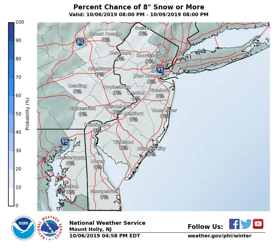
Toms River now in the less than 1" band (down from 2"); Freehold at 4" (down from 7"), New Brunswick 7" (down from 9"), and Morristown at 10" (down from 12"). Yes, the storm can shift, but NWS is less bullish with the latest update. Here is the 3:20 a.m. map, which usually reverts to the previous one (it reverted, so here is the % chance of 8" or more).
Well, the UK
Even better consensus on a major to possibly historic (at least for March, which has only had 5 snowstorms of 12" or more in NYC) snowstorm along/near I-95 from Trenton to NYC and NW of there tonight. Every major global model (and two main mesoscale models) shows at least 8-12" of snow (using a 10:1 snow to liquid ratio, which might be a bit high) from Trenton to NYC, with most models showing 12-18" (with a little less towards Philly along 95); the one exception to this is the GFS, which shows 4-8" from Trenton to NB and 8-12" from NB to NYC. And for areas just a bit NW of 95 out to 75-100 miles or so NW of 95, it's looking like 12-18" is becoming quite likely - and 18-24" snowfalls are on the table for much of the region, as per a couple of models showing more precip.
However, the gradient from 95 SE to the coast is pretty steep, with the immediate coast getting more like 2-4/4-8", with substantial amounts of rain - model soundings are not showing a sleet signature (warm air aloft/below 32F for the last 1000 feet to the surface) or a freezing rain signature (warm air aloft and below 32F just at the surface), but a rain signature with the column being below 32F until the last 300-500 feet above the surface being above 32F, melting the snow to rain.
It would only take a track shift of 25-50 miles NW of the current track to turn the I-95 accumulations into the Dover, DE to Toms River accumulations of maybe 2-6". Similarly a shift of 25-50 miles SE of the current track would turn the Dover to Toms River accumulations into 8-12/12-18" amounts, depending on the model. And track shifts of that magnitude are clearly possible 30 hours before the start of an event, although I wouldn't consider it "likely" (there's a reason why major busts like Jan 15 and March 01 are remembered so well - 50 mile shifts very late in the game are unusual).
Since it's kind of fun guessing what the NWS will do and I've gotten to be ok at it, I fully expect to see winter storm warnings at 4 am for all the counties that currently have watches (along 95 down to Wilmington and from Mercer over to Monmouth and everything north of 195 and NW of I-95) and perhaps winter storm watches for Ocean and the rest of SE NJ. And it's possible we see blizzard warnings sometime tomorrow for locations expected to get heavy snow and winds, like NYC, LI and maybe Middlesex and Monmouth (I think they'll want to see the 12Z runs tomorrow afternoon first to be sure).
Got it partly right. NWS in Philly went with warnings for 7-10" for the counties along and NW of 95 from Delaware County through Philly, Mercer and Middlesex, while retaining the watches for the counties just to the SE of that, i.e., on the NJ side of the Delaware south of Trenton and for Monmouth, for 1-3" and up to 7" locally, since they're just not sure where the rain snow line will be.
For areas NW of the I-95 counties with 7-10" warnings, warnings are up for 10-14". Snowfall maps were actually reduced from 4 pm for the area near and along 95 and SE of there, which surprised me given the 00Z model outputs looked to be as bullish or slightly more bullish than 12Z, especially the Euro. Snowfall amounts were also generally lowered by 1-2" for the NW counties with all snow, presumably due to less precip. Here are the two maps for comparison.
For the NWS in NYC, they went simpler, issuing warnings for their entire area of NYC, NE NJ, Nassau, CT and the Lower Hudson Valley for 6-12" of snow, noting that 10-15" were possible for interior portions of the Hudson Valley and CT. Suffolk and southern Nassau are under watches for 4-8".
Edit: added the map of warnings (pink) and watches (blue); haven't seen an updated NWS NYC map and I need to get some sleep...
Edit at 8:25 am - woke up and added in NWS NYC map from 4 am and yesterday from 4 pm for completeness. Interesting that they increased snowfall, while the Philly office decreased. Time to read the AFDs to find out why...


Last edited:


WCTC 5-10 inches for listening area
Weather Channel 8-12 Hillsborough
Dan Zarrow 101.5 10-14 Somerset County Shift 30 miles west 4-9 inches less snow shift east up to 16 and he has seen models over 18 inches. Dan is usually conservative.
Weather Channel 8-12 Hillsborough
Dan Zarrow 101.5 10-14 Somerset County Shift 30 miles west 4-9 inches less snow shift east up to 16 and he has seen models over 18 inches. Dan is usually conservative.
Last edited:
There will be MILF's at a certain Deli that'll be really disappointed if they're expecting 8-10" but only get 5".
Just came back from getting an everything bagel with cream cheese. Don't know if it's the storm or if it's just Tuesday but the place was packed with milf's sporting yoga pants and I saw a few sporting Rutgers hoodies.
It sounds like Al should play hooky today and head over to the Hillsborough Deli.Just came back from getting an everything bagel with cream cheese. Don't know if it's the storm or if it's just Tuesday but the place was packed with milf's sporting yoga pants and I saw a few sporting Rutgers hoodies.
I think at the moment a general 6-12 inches for CJ is a pretty good call...3-6 to shore (coast to inland) and 8-14 north of 78 with lollipops of 16.
6z GFS continues to be warm....so warm I didnt see a snow map posted. 6z NAM had ticked a bit west again and that west movement has to stop for those wanting widespread big snows
12z NAM is rolling in now. These are going to be important runs in the next few hours to pick up on any shifts
6z GFS continues to be warm....so warm I didnt see a snow map posted. 6z NAM had ticked a bit west again and that west movement has to stop for those wanting widespread big snows
12z NAM is rolling in now. These are going to be important runs in the next few hours to pick up on any shifts
well the 12Z NAM ticked even further west....raising dry slotting issues for part of NJ and NYC and moving the best totals to the NW.....see the gradual cut again in totals on Kuchera..2nd time in a row

10-1 for Numbers

10-1 for Numbers
6Z GFS this morning moved the rain line NW about 25 miles cutting snow totals down for I-95 and the 12Z NAM just did the same (maybe 4-8" of snow for Trenton to NYC, which is what the NWS kind of has), so if you love snow, you have to be at least concerned this could become wetter than white for 95. Could also be a blip/wobble. Hard to say.
11 am edit: 12Z GFS has very little snow and mostly rain for the 95 corridor as the track moved west. The 12Z RDPS (mesoscale model, like the NAM) shows 1-2 feet of snow. So yeah, easy forecast. Let's see what Dr. No (Euro) and the UK say.
11:40 am edit. Model mayhem in full force. 12Z HRDPS (high res version of the RDPS) is a huge hit and the CMC continues to be a good hit for 95, while the UK supposedly "looks good" from a pro met (that model isn't available easily). So, yeah, easy forecast.
11 am edit: 12Z GFS has very little snow and mostly rain for the 95 corridor as the track moved west. The 12Z RDPS (mesoscale model, like the NAM) shows 1-2 feet of snow. So yeah, easy forecast. Let's see what Dr. No (Euro) and the UK say.
11:40 am edit. Model mayhem in full force. 12Z HRDPS (high res version of the RDPS) is a huge hit and the CMC continues to be a good hit for 95, while the UK supposedly "looks good" from a pro met (that model isn't available easily). So, yeah, easy forecast.
Last edited:

What is the origin of the Hillsborough Deli Milfs joke?
You have to be 21 to hear it, but you can google it if your parents aren't home

Latest
-
01
 The Knight Report
Rutgers vs Indiana odds: Point spread released on Scarlet Knights, Hoosiers
The Knight Report
Rutgers vs Indiana odds: Point spread released on Scarlet Knights, Hoosiers
-
02
 The Knight Report Football
Every throw from Rutgers Football QB Dylan Lonergan versus Howard
The Knight Report Football
Every throw from Rutgers Football QB Dylan Lonergan versus Howard
-
03
 The Knight Report
Rutgers Football PFF Grades + Snap Counts versus Howard
The Knight Report
Rutgers Football PFF Grades + Snap Counts versus Howard
-
04
 The Knight Report
Rutgers Football Postgame Show: Howard Bison Edition - TKR Pod
The Knight Report
Rutgers Football Postgame Show: Howard Bison Edition - TKR Pod
-
05
 On3 Football
How to Watch College Football: TV schedule, start times, streaming info for Week 4 games
On3 Football
How to Watch College Football: TV schedule, start times, streaming info for Week 4 games