Lee Goldberg just upped his snowfall forecasts across the board. Has the 12" line running from about New Hope to Warren to Paramus to White Plains, with 12-18" NW of that line and has the 6" line running from Glassboro to Jackson to Sandy Hook with 6-12" NW of that line up to the 12" line, which would obviously include the I-95 corridor, which is smack dab in the middle of that 6-12" swath (or 9-10"). The 3" line runs from Millville to Toms River, with 3-6" NW of that line to the 6" line, and the 1-3" swath goes from the 3" line to the coast. I'll look for a map on line, but he's the best in NYC IMO and this looks like a solid forecast.
OT: Potential Winter Storm on 3/7-8
- Thread starter RU848789
- Start date
You are using an out of date browser. It may not display this or other websites correctly.
You should upgrade or use an alternative browser.
You should upgrade or use an alternative browser.
Lee Goldberg just upped his snowfall forecasts across the board. Has the 12" line running from about New Hope to Warren to Paramus to White Plains, with 12-18" NW of that line and has the 6" line running from Glassboro to Jackson to Sandy Hook with 6-12" NW of that line up to the 12" line, which would obviously include the I-95 corridor, which is smack dab in the middle of that 6-12" swath (or 9-10"). The 3" line runs from Millville to Toms River, with 3-6" NW of that line to the 6" line, and the 1-3" swath goes from the 3" line to the coast. I'll look for a map on line, but he's the best in NYC IMO and this looks like a solid forecast.
This?Lee Goldberg just upped his snowfall forecasts across the board. Has the 12" line running from about New Hope to Warren to Paramus to White Plains, with 12-18" NW of that line and has the 6" line running from Glassboro to Jackson to Sandy Hook with 6-12" NW of that line up to the 12" line, which would obviously include the I-95 corridor, which is smack dab in the middle of that 6-12" swath (or 9-10"). The 3" line runs from Millville to Toms River, with 3-6" NW of that line to the 6" line, and the 1-3" swath goes from the 3" line to the coast. I'll look for a map on line, but he's the best in NYC IMO and this looks like a solid forecast.
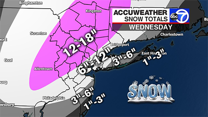
Is this right the Howell/Freehold area just went from 2" to 4" to 8" to 10"? And the Toms River area just went from.5" to roughly 5"? While the Weather Channel says nothing but rain/slush for my area. I'm so confused. You know this stuff, I'm clueless.
The current 00Z models are definitely showing more snow for those areas and forecasters are responding - see my Lee Goldberg post. He has Freehold in the 6-12" swath (closer to 6" as it's near the 6" line) and has Toms River right on the 3" line. For those locations, especially Toms River, keep in mind with some to a lot of mixing with rain, accumulations will be harder to come by, but this is no longer looking like a rainstorm for those locations as it kind of was earlier today. Will be dumbfounded if the NWS doesn't put out revised maps like Lee's by 4 am.

This?
Ugh. My area went from 1-3 this afternoon to 6-12
And the 00Z Canadian (CMC/GGEM) global model just came in similar to earlier, which is very snowy for 95 and toward the coast somewhat. All the 00Z models are back in my post a few pages back, but I'm guessing nobody is seeing those, so I'm also posting as they come out. UK to come and the all important Euro.

Another model, the 00Z HRDPS, the Canadian version of the US's high resolution 3 km NAM. Big hit for everyone including most of the coast.

And the UKMET model from the UK (generally the 2nd best model behind the Euro) is reportedly "beautiful," as per a pro/snow lover on 33andrain, moving SE of where it was tracking earlier, which is a consistent theme tonight - has big snows for most.
And last but not least, King Euro, Dr. No, comes in with a big hit. Definitely time to extend the warnings and increase snowfall forecasts for most, including the NWS (which I'm sure they will), just like Lee Goldberg did.

Another model, the 00Z HRDPS, the Canadian version of the US's high resolution 3 km NAM. Big hit for everyone including most of the coast.
And the UKMET model from the UK (generally the 2nd best model behind the Euro) is reportedly "beautiful," as per a pro/snow lover on 33andrain, moving SE of where it was tracking earlier, which is a consistent theme tonight - has big snows for most.
And last but not least, King Euro, Dr. No, comes in with a big hit. Definitely time to extend the warnings and increase snowfall forecasts for most, including the NWS (which I'm sure they will), just like Lee Goldberg did.
Last edited:
This?
Thank you. This is definitely way different than earlier. I'll be getting my running around for work done earlier tomorrow than I had planned. I thought this was just going to be a 2" slush event for my area. I'll just head out earlier.The current 00Z models are definitely showing more snow for those areas and forecasters are responding - see my Lee Goldberg post. He has Freehold in the 6-12" swath (closer to 6" as it's near the 6" line) and has Toms River right on the 3" line. For those locations, especially Toms River, keep in mind with some to a lot of mixing with rain, accumulations will be harder to come by, but this is no longer looking like a rainstorm for those locations as it kind of was earlier today. Will be dumbfounded if the NWS doesn't put out revised maps like Lee's by 4 am.
I'm in the same boat.Ugh. My area went from 1-3 this afternoon to 6-12

What is the approx timeline for the snow to start and then really pick up for Union County-ish area?
Like, in the morning commute, it will be light snow and then pick up heavy mid morning?
Like, in the morning commute, it will be light snow and then pick up heavy mid morning?
That's basically it.What is the approx timeline for the snow to start and then really pick up for Union County-ish area?
Like, in the morning commute, it will be light snow and then pick up heavy mid morning?
Cool thanks!That's basically it.
Also, wanna let u know that I, and probably a whole lot of other Rutgers fans really appreciate all the snow threads through the years. I always try and look for your threads first to find out the latest info.
It has always been very helpful and I have learned a whole lot that I never knew or would not have known just by reading your posts
Last edited:
One more post tonight. I expect the NWS will take note of the more bullish model near consensus and expand the warnings to all of NJ, except maybe Atlantic, Cape May and Cumberland (and to the rest of LI/CT), as well as raise the snowfall forecasts to something like 12-18” just NW of 95, 8-14” likely along and within maybe 20-25 miles SE of 95, where mixing with rain should be minimal (and confined to the locations closer to the coast in that swath) and even 4-8” for coastal sections, This is actually pretty similar to what Lee Goldberg on Channel 7 showed earlier (see above), as he also increased snowfall amounts significantly vs. earlier this evening.
Having said all that, even at this late stage, with the storm taking shape, it's highly unlikely, but possible, that the outcome could change to a wetter solution, like it was earlier today or an even less wet solution, by a track shift of ~25 miles either way, but shifts greater than that are extremely unlikely. But have happened at least 2X that I can think of this late for this big of a storm, resulting in major busts - March 2001 and Jan 2015 - I'm sure more than a few are wishing for that. Be safe out there and try to enjoy the beauty of it all and/or go out and play in it with your kids.
Having said all that, even at this late stage, with the storm taking shape, it's highly unlikely, but possible, that the outcome could change to a wetter solution, like it was earlier today or an even less wet solution, by a track shift of ~25 miles either way, but shifts greater than that are extremely unlikely. But have happened at least 2X that I can think of this late for this big of a storm, resulting in major busts - March 2001 and Jan 2015 - I'm sure more than a few are wishing for that. Be safe out there and try to enjoy the beauty of it all and/or go out and play in it with your kids.

But unlike George a lot of us will not get there!We all have places to go! [roll]

Where is #'s the Snow Miser getting his numbers (non pun intended) for 6+ inches? Is the NWS on a banana boat?
Still snowing? You are about 20 miles southwest of me.Snowing right now in Manchester,but seems almost warm.Nothing is sticking on the yard or road.
Up here in Flanders my wife's car, the grass ( where the snow melted from Friday's storm) and roof's are all covered now. The pavement has little snow on it.


Looks like they ran the 0" further north along the coastline. Raining here still.Got about an inch and half down here in Wayne already
Looks like the NWS upped totals one last time at 4AM:


Stop taking pictures and get shoveling!Okay, one quick shot from 5AM:

Rain in Cranford. Just saw a few snow flakes floating around. Run for cover! Close the schools!
Rain in Cranford. Just saw a few snow flakes floating around. Run for cover! Close the schools!
Patience grasshopper...lol
In Alaska?Dan Zarrow 101.5 upped his totals. Said we can see 3-4 inches an hour at some point.
In Alaska?
Nope N and C NJ. Thundersnow also. This guy is pretty conservative too.
I don't trust Republican weather people.Nope N and C NJ. Thundersnow also. This guy is pretty conservative too.

you do realize that regardless of how much he loves snow or how much he talks about it or how much he wishes for it, the snow will still come down don't you? If he said he hated it and cursed it, would that make the snow go away or bring power back to those who don't have? I find it kind of funny how some of you get so upset at #s love for snow. I hate snow but I can also appreciate its beauty and find a big powerful storm pretty fascinating. I also find it an inconvenience but I don't get upset at #s when I see it coming down.Bruh...this is when you go all bazinga! on us.
Take it down a notch....office voice/posts
(and I know you don’t mean to do this)
Last edited:
and remember to turn the shovel over this time... [winking]Stop taking pictures and get shoveling!
I don't trust Republican weather people.
Can you take a quick ride to Rumson and let me know the conditions over there? Ever since you moved I have not gotten my Rumson weather reports. I need to know if I should pack my caviar for lunch today.
good solid snowfall just started here west of flemington.just changed from very light flakes. inch on the ground but pavement clear.

Latest
-
01
 The Knight Report
Early Recruit Visitor list for Rutgers Football versus Indiana
The Knight Report
Early Recruit Visitor list for Rutgers Football versus Indiana
-
02
 The Knight Report Football
ESPN FPI projects Rutgers Football's 2026 schedule - Week Four
The Knight Report Football
ESPN FPI projects Rutgers Football's 2026 schedule - Week Four
-
03
 The Knight Report
Rutgers vs Indiana odds: Point spread released on Scarlet Knights, Hoosiers
The Knight Report
Rutgers vs Indiana odds: Point spread released on Scarlet Knights, Hoosiers
-
04
 The Knight Report Football
Every throw from Rutgers Football QB Dylan Lonergan versus Howard
The Knight Report Football
Every throw from Rutgers Football QB Dylan Lonergan versus Howard
-
05
 The Knight Report
Rutgers Football PFF Grades + Snap Counts versus Howard
The Knight Report
Rutgers Football PFF Grades + Snap Counts versus Howard