OT: Official Hurricane Irma Thread
- Thread starter RU4Real
- Start date
You are using an out of date browser. It may not display this or other websites correctly.
You should upgrade or use an alternative browser.
You should upgrade or use an alternative browser.
Only with respect to the synoptic conditions prevalent during the period. Jeeze some of you guys need this spoon fed!Does this mean it's looking like a Florida landfall?
Only with respect to the synoptic conditions prevalent during the period. Jeeze some of you guys need this spoon fed!
"Does this mean Anne Margret won't be coming?"
Joker- Full Metal Jacket
Updated track from the NHC - even further SW, hitting Cuba at Day 5 and possibly clipping the NE coast of Puerto Rico - makes landfall on the US east coast even less likely; Florida and even the eastern GOM, including the FL Gulf coast, are now becoming more likely. That WAR (western Atlantic ridge) pushing Irma to the WSW is being modeled as quite strong over the next several days. Gotta run...
Thanks Knightfan, this is what I was looking for. The whole trend shifted west between 5-10 degrees lat. Will be interesting to see if this western slide continues. Tx.. La... Ouch.


"Does this mean Anne Margret won't be coming?"
Joker- Full Metal Jacket
Well of course it depends on the synoptic... blah blah blah. LOL
So fascinating agreement between the 12Z Euro and the 12Z GFS through the 120. Both take Irma just barely by the northern side of Cuba into the Keys. There's some separation in the northward turn and some track variances post-144 hours. Both models show a secondary landfall near the GA-SC border followed by a rapid loss of intensity and transition to extra-tropical.
As with many tropical systems going through this region, when and where Irma finally makes that turn to the north is so critical to where it makes landfall, especially given the geography of the Florida coast. Making the turn 50 miles sooner or later, which is a tiny variation in the grand scheme of things for a hurricane's overall track (and impossible to predict this far out, let alone a day out, as we saw with Matthew last year), has huge implications for going up either the west coast or the east coast or the center of Florida, for example.
FYI, my posts will likely be limited the next few days (father-in-law, who's 96, is quite ill and in the hospital).
FYI, my posts will likely be limited the next few days (father-in-law, who's 96, is quite ill and in the hospital).
Does it now look like Irma is hitting US--question is where?
As of now there's pretty good agreement on a very close pass with southern Florida in 6 days. Precisely where is unclear.
It should also be noted that the 0Z runs tonight are going to have a LOT more data to ingest, as there will have been at least 2 recon flights into Irma before those models initialize. So, it's entirely possible that come tomorrow morning we'll have a slightly different look.
Becoming more likely, but out-to-sea is still possible - we're still 6+ days away from any US landfall.Does it now look like Irma is hitting US--question is where?
As with many tropical systems going through this region, when and where Irma finally makes that turn to the north is so critical to where it makes landfall, especially given the geography of the Florida coast. Making the turn 50 miles sooner or later, which is a tiny variation in the grand scheme of things for a hurricane's overall track (and impossible to predict this far out, let alone a day out, as we saw with Matthew last year), has huge implications for going up either the west coast or the east coast or the center of Florida, for example.
FYI, my posts will likely be limited the next few days (father-in-law, who's 96, is quite ill and in the hospital).
Sorry to hear that. Take care of your thing, I got this one.
") All the best to your family.
All the best to your family.Yep, the same. Do what you gotta do. I'll take care of the riff-raff!Sorry to hear that. Take care of your thing, I got this one.
Is this the run you referred to above?The 18Z GFS skips the northern coast of Cuba and slams into the southern tip of the Florida peninsula as a high Cat 4 / low Cat 5.
The governor of Florida has declared a state of emergency as preparations are initiated.
As with many tropical systems going through this region, when and where Irma finally makes that turn to the north is so critical to where it makes landfall, especially given the geography of the Florida coast. Making the turn 50 miles sooner or later, which is a tiny variation in the grand scheme of things for a hurricane's overall track (and impossible to predict this far out, let alone a day out, as we saw with Matthew last year), has huge implications for going up either the west coast or the east coast or the center of Florida, for example.
FYI, my posts will likely be limited the next few days (father-in-law, who's 96, is quite ill and in the hospital).
All my best RU848789.....
#'s - All our prayers and best wishes for your Father In Law. Phil
As with many tropical systems going through this region, when and where Irma finally makes that turn to the north is so critical to where it makes landfall, especially given the geography of the Florida coast. Making the turn 50 miles sooner or later, which is a tiny variation in the grand scheme of things for a hurricane's overall track (and impossible to predict this far out, let alone a day out, as we saw with Matthew last year), has huge implications for going up either the west coast or the east coast or the center of Florida, for example.
FYI, my posts will likely be limited the next few days (father-in-law, who's 96, is quite ill and in the hospital).
Best wishes to your father in law and family.
Is this the run you referred to above?
No, I was talking about the 0Z, which is running now. They'll be up in a few hours and will include the additional data from today's recon flights.
Dolphins/Bucs game gonna go on as scheduled?
The state of Florida is already under a state of emergency as of earlier tonight. If the guidance picture doesn't change before, say, Wednesday... I would think they'd reschedule the game.
Sorry to hear that. Take care of your thing, I got this one.
Sorry to hear, Numbers.
I wish him the best.
All my best RU848789.....
#'s - All our prayers and best wishes for your Father In Law. Phil
Best wishes to your father in law and family.
#'s - we're hoping for the best for your father in law.
Thanks, all, much appreciated - like any "family" we often argue or fight about generally trivial things, but whenever anyone posts about anything remotely serious, it's always nice to see the support everyone gets around here. Anyway, when someone is 96 you tend to try to focus on a life very well lived, but it's obviously still sad for my wife and her siblings. When all this is over, I'll post a thread on him, as he was quite an interesting guy, who I've posted about a few times before (WWII vet, RU prof, etc.). For now, my role is moral support - I'm sure most of you have been there.
Will still be tracking this, though, as my dad lives in Vero (and lived through Jeanne and Frances in 2004 and said "never again"), as does my sister and her SO, although they're in Delaware for the summer, and they all like getting updates on storms that might hit there.
Don Sutherland, one of the absolute best posters on AmericanWx, who seemingly has every cool piece of meteorological/climatological data at his fingertips and knows how to use that info, just made an awesome post about the past history of the 32 hurricanes which were at or close to Irma's location over the past 166 years, wherein 41% of them made US landfalls (and 54% of those landfalls were in FL). Worth a read.
https://www.americanwx.com/bb/topic/50217-major-hurricane-irma/?do=findComment&comment=4609030
With Irma having tracked generally west-southwestward for much of the day before turning to the west, it has reached a position with a much greater climatological risk of landfall. Since 1851, 32 hurricanes have passed within 100 miles of Irma's 8 pm position of 16.7°N 55.0°W. 13/32 or 41% made U.S. landfall and 7 of the 13 (54%) storms that made landfall made their first landfall in Florida. The majority of such hurricanes were major hurricanes at U.S. landfall. The following details follow from the above sample:
Classification of Hurricanes at First U.S. Landfall:
Category 1: 8%
Category 2: 15%
Category 3: 31%
Category 4: 46%
First U.S. Landfall at Florida:
Hurricane #4 (1871): Category 3
1926 “Great Miami Hurricane:” Category 4
1928 “Lake Okeechobee Hurricane:” Category 4
Hurricane #4 (1947): Category 4
Donna (1960): Category 4
Inez (1966): Category 1
Georges (1998): Category 2
Considering a blend of the climatology associated with hurricanes passing in the vicinity where Irma has tracked and the ensembles/operational guidance, my thinking is that U.S. landfall is now a 75% probability. The area of greatest risk has shifted south to Florida with the wider Florida-North Carolina region at highest risk. Small possibilities exist for Irma to enter the Gulf of Mexico and then track to Alabama or westward or for Irma to head for the Virginia-New England area based largely on climatology.
Latest email update - contains some repeat nuggets from yesterday, but thought people might find this of interest...
People in much of Florida need to start preparing now and consider evacuating in a couple of days, as the model consensus is getting pretty strong for a Florida landfall in 5-6 days (although still not a given); see the track "spaghetti plots" below.
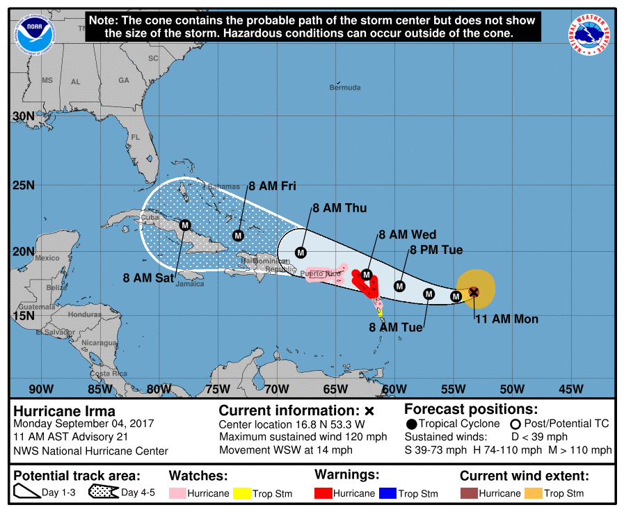
Updated NHC report has Irma as a strong Cat 4 system with 150 mph winds and the forecast track has it going right over the northernmost of the Leeward Islands, (Barbuda, Anguilla and the British Virgin Islands) over the next 1-2 days, then just north of Puerto Rico, Hispaniola and Cuba in the next 2-4 das, but close enough to have hurricane conditions on those islands - and any southward shift in the track could bring a direct hit to any of them.
The track then brings Irma to the Florida Keys at the end of the 5-day forecast period, as a slightly weaker storm with 130 mph winds, as its closeness to Cuba will disrupt the circulation at least somewhat. Irma could strengthen a bit just before any landfall in South Florida or the Keys, if it makes a landfall there, which is becoming a pretty good probability, but not a given yet, as track errors at 5 days are 225 miles across (125 miles in either direction from the center line).
Those track errors do mean Irma could go over the Keys and head into the Gulf and up to the Florida panhandle or could still make the turn north early enough to miss Florida, staying off the east coast of Florida and then possibly hitting the Carolinas or just going out to sea, but those possibilities are becoming less likely as we get closer to the event (for Florida).
Here's the dilemma, though for forecasters with a storm likely to move mostly west or WNW for days and then scheduled to make a sharp turn to the north around Day 5: as with many tropical systems, when and where Irma finally makes that turn to the north is so critical to where it makes landfall, especially given the geography of the Florida coast. Making the turn 50 miles sooner or later, which is a tiny variation in the grand scheme of things for a hurricane's overall track (and impossible to predict this far out, let alone a day out, as we saw with Matthew last year), has huge implications for going up either the west coast or the east coast or the center of Florida, for example.
Assuming a Florida landfall, damage could be catastrophic with regard to storm surge and wind damage, as would be expected for a landfalling major hurricane. Flooding rains will also fall, although no models show the stall we saw for Harvey, so ridiculous 20"+ rains are very unlikely, but 10-20" rains can still lead to major flooding.
Final note: impacts in the Philly to NYC corridor are likely to be limited to wherever the remains of Irma go, inland, assuming a landfall. Could be minimal impacts if it goes well inland to our west or could be major, with soaking/flooding rains and high winds possible, maybe even up to tropical storm force under certain scenarios. No models are showing a miss off the Florida east coast and then a Sandy like hook into NJ as a hurricane - if it goes east of the Florida coast that likely means it might hit the Carolinas (and then come close to here as a greatly weakened tropical storm, but still potentially dangerous) or just go harmlessly out to sea.
Lastly, take a look at the IR view of Irma, below. Gorgeous and frightening at the same time...


People in much of Florida need to start preparing now and consider evacuating in a couple of days, as the model consensus is getting pretty strong for a Florida landfall in 5-6 days (although still not a given); see the track "spaghetti plots" below.
Updated NHC report has Irma as a strong Cat 4 system with 150 mph winds and the forecast track has it going right over the northernmost of the Leeward Islands, (Barbuda, Anguilla and the British Virgin Islands) over the next 1-2 days, then just north of Puerto Rico, Hispaniola and Cuba in the next 2-4 das, but close enough to have hurricane conditions on those islands - and any southward shift in the track could bring a direct hit to any of them.
The track then brings Irma to the Florida Keys at the end of the 5-day forecast period, as a slightly weaker storm with 130 mph winds, as its closeness to Cuba will disrupt the circulation at least somewhat. Irma could strengthen a bit just before any landfall in South Florida or the Keys, if it makes a landfall there, which is becoming a pretty good probability, but not a given yet, as track errors at 5 days are 225 miles across (125 miles in either direction from the center line).
Those track errors do mean Irma could go over the Keys and head into the Gulf and up to the Florida panhandle or could still make the turn north early enough to miss Florida, staying off the east coast of Florida and then possibly hitting the Carolinas or just going out to sea, but those possibilities are becoming less likely as we get closer to the event (for Florida).
Here's the dilemma, though for forecasters with a storm likely to move mostly west or WNW for days and then scheduled to make a sharp turn to the north around Day 5: as with many tropical systems, when and where Irma finally makes that turn to the north is so critical to where it makes landfall, especially given the geography of the Florida coast. Making the turn 50 miles sooner or later, which is a tiny variation in the grand scheme of things for a hurricane's overall track (and impossible to predict this far out, let alone a day out, as we saw with Matthew last year), has huge implications for going up either the west coast or the east coast or the center of Florida, for example.
Assuming a Florida landfall, damage could be catastrophic with regard to storm surge and wind damage, as would be expected for a landfalling major hurricane. Flooding rains will also fall, although no models show the stall we saw for Harvey, so ridiculous 20"+ rains are very unlikely, but 10-20" rains can still lead to major flooding.
Final note: impacts in the Philly to NYC corridor are likely to be limited to wherever the remains of Irma go, inland, assuming a landfall. Could be minimal impacts if it goes well inland to our west or could be major, with soaking/flooding rains and high winds possible, maybe even up to tropical storm force under certain scenarios. No models are showing a miss off the Florida east coast and then a Sandy like hook into NJ as a hurricane - if it goes east of the Florida coast that likely means it might hit the Carolinas (and then come close to here as a greatly weakened tropical storm, but still potentially dangerous) or just go harmlessly out to sea.
Lastly, take a look at the IR view of Irma, below. Gorgeous and frightening at the same time...
Last edited:
This storm is a monster.
Recon this morning found flight level winds close to 200 mph and the latest surface data is topping 150 mph. Irma will be a Cat 5.
Whether or not she remains a Cat 5 upon nearing southern Florida is dependent upon the extent of her interaction with the Cuba land mass. The Euro is showing an extended encounter with the island, which would allow the storm to decay somewhat prior to reaching the Keys. The GFS continues to suggest a pass further to the north, which would allow Irma to maintain her strength into the Keys and the southern tip of the Florida peninsula.
Either way, this is a very, very dangerous hurricane. Interests in southern Florida and the Florida Keys should be preparing for the worst, come next weekend.
Holy crap. Cat 5 175 mph winds and down to 929 mbar pressure, as of 8 am advisory and about to destroy the northern Leeward Islands. And the NHC upped their forecast strength at 120 hours to 150 mph, which is almost Cat 5, as it approaches Florida. Serious, serious storm.
http://www.nhc.noaa.gov/text/refresh/MIATCDAT1+shtml/DDHHMM.shtml?
http://www.nhc.noaa.gov/text/refresh/MIATCDAT1+shtml/DDHHMM.shtml?
It is not just Florida but Puerto Rico and the US Virgin Islands, they are all Americans as well, and they are tiny in scale with this monster. They don't have the resources to withstand something like this. I am scared for them as well as South Florida.
Dumb question but I'll ask anyway.
If Irma were to track straight up the center of Florida would it break down over land or is it just too big and powerful? In that scenario would it likely still be a major hurricane as it hit the Ga border?
If Irma were to track straight up the center of Florida would it break down over land or is it just too big and powerful? In that scenario would it likely still be a major hurricane as it hit the Ga border?
Dumb question but I'll ask anyway.
If Irma were to track straight up the center of Florida would it break down over land or is it just too big and powerful? In that scenario would it likely still be a major hurricane as it hit the Ga border?
Interaction with land will definitely degrade the storm. There's a lot that goes into figuring out how much, but hurricanes need warm water to survive.
Concern around Irma is growing. This link to a GOES-16 sat loop may take a while to load, but the imagery shouldn't be missed.
Dumb question but I'll ask anyway.
If Irma were to track straight up the center of Florida would it break down over land or is it just too big and powerful? In that scenario would it likely still be a major hurricane as it hit the Ga border?
No dumb questions in a situation like this - it's actually a great question. Most hurricanes that traverse some or much of Florida weaken somewhat, but since the topography is so flat, weakening is nowhere near what's seen for locations like Cuba with many mountains. Donna in 1960 is an interesting analog to Irma - it "only" dropped from 140 mph in the Keys to 105 mph exiting the coast at Daytona Beach.
While passing through the Straits of Florida, Donna brushed the northern coast of Cuba on September 9 with gale-force winds. Subsequently, a cold front moved eastward through the United States and weakened the ridge, causing the hurricane to turn more to the northwest. It re-intensified over warm sea surface temperatures,[1] and the hurricane's minimum barometric pressure dropped to 932 mbar (27.5 inHg) on September 10.[4] Between 0200 and 0300 UTC that day, the 21 mi (34 km) wide eye of Donna crossed through the Florida Keys just northeast of Marathon, with sustained winds of 140 mph (230 km/h) and gusts to 178 mph (286 km/h). The hurricane continued to the northwest along the southwest coast of Florida, passing over Naples and Fort Myers before turning inland to the northeast. At 0800 UTC on September 11, Donna exited Daytona Beach into the western Atlantic with winds of about 105 mph (165 km/h), still as an organized hurricane. Accelerating to the northeast due to an approaching trough, the hurricane re-intensified slightly before making landfall near Wilmington, North Carolina, early on September 12. At 0900 UTC that day, Donna again emerged over open waters near Virginia, although it had weakened and the eye expanded to over 50 mi (80 km) in diameter. Late on September 12, the hurricane made landfall in Westhampton, New York and crossed Long Island, later moving into New England.[1] On September 13, Donna became extratropical over northern Maine before entering eastern Canada, having become associated with the approaching cold front. After moving across Quebec and Labrador, Donna reached the Labrador Sea and dissipated early on September 14.[1][4]
https://en.wikipedia.org/wiki/Hurricane_Donna
It is not just Florida but Puerto Rico and the US Virgin Islands, they are all Americans as well, and they are tiny in scale with this monster. They don't have the resources to withstand something like this. I am scared for them as well as South Florida.
The northern US Virgin Islands and the British Virgin Islands in particular to the east are in the crosshairs for a direct hit. NE Puerto Rico will have a close call being maybe 30-50 miles south of Irma's center, such that they'll likely get hurricane force winds and major rains, hopefully not catastrophic impacts, again, if Irma stays on track for the next 36 hours, which is when it will come closest to PR. But even a small detour south could lead to a catastrophic impact on NE Puerto Rico (and San Juan). Both locations will also be on the weaker, SW side of the storm.
Also, the northeasternmost Leeward Islands like Barbuda and Antigua will likely get a direct hit or very close to it, which will likely have catastrophic impacts in the next 24 hours. Turks and Caicos and the SW-ern Bahamas are also under the gun for a direct hit from this Cat 5 storm - and they likely will be on the stronger NE side of the storm.
Edited the above, as I had the locations off on the original...
Last edited:
Yesterday there were some moderate suggestions from TWC that this thing could strengthen a little, but then this morning it's a full blown cat 5.
Was TWC playing it conservatively(from my experience this is highly unlikely) or was that a very unexpected jump?
Just looking at the satellite, this thing is as symmetrical as it can get. It's prototype shape.
Was TWC playing it conservatively(from my experience this is highly unlikely) or was that a very unexpected jump?
Just looking at the satellite, this thing is as symmetrical as it can get. It's prototype shape.
Beware Irma!

seriously.. seeing the Houston cleanup going on.. houses still underwater and this monster on the way.. I worry for the keys.. how big is the storm surge if it doesn't hit Cuba on the way? Will those keys just be completely underwater?
OMG.. that animated gif of the storm above had loaded in another window and I just saw it.. wow. That is some tight rotation. Where does the ocean end and the clouds begin? How tall is that wall inside the eye?
Last edited:
The northern US Virgin Islands and the British Virgin Islands in particular to the east are in the crosshairs for a direct hit. NE Puerto Rico will have a close call being maybe 50 miles south of Irma's center, such that they'll likely get hurricane force winds and major rains, but again, unlikely to be catastrophic impacts, again, if Irma stays on track for the next 36 hours, which is when it will come closest to PR. But even a small detour south could lead to a catastrophic impact on NE Puerto Rico (and San Juan). Both locations will also be on the weaker, SW side of the storm.
Also, the northeasternmost Leeward Islands like Barbuda and Antigua will likely get a direct hit or very close to it, which will likely have catastrophic impacts in the next 24 hours. Turks and Caicos and the SW-ern Bahamas are also under the gun for a direct hit from this Cat 5 storm - and they likely will be on the stronger NE side of the storm.
Edited the above, as I had the locations off on the original...
Thank you for the update.
My parents retired and move to Puerto Rico years ago so I am keeping a close eye on this one, they live in the North Western part however. Hopefully they will just get rain and not much else. East side of the island looks like it will get flooding and mud slides again.
Dumb question but I'll ask anyway.
If Irma were to track straight up the center of Florida would it break down over land or is it just too big and powerful? In that scenario would it likely still be a major hurricane as it hit the Ga border?
I was wondering the same. My in-laws retired this year to Bradenton, Florida (basically SE Tampa Bay). There was a great article in the Washington Post a couple months ago about how Tampa has not been directly hit by a hurricane since the 1930s (I think) and really isn't prepared for it. But to be fair, with a Cat 5 monster, who is? Anyway, models show this thing potentially hooking a right turn and hugging the west coast of Florida or moving up the center of the state. People on here who know far more about this, am I looking at that correctly?
Last edited:
I was wondering the same. My in-laws retired this year to Bradenton, Florida (basically SW Tampa Bay). There was a great article in the Washington Post a couple months ago about how Tampa has not been directly hit by a hurricane since the 1930s (I think) and really isn't prepared for it. But to be fair, with a Cat 5 monster, who really is? Anyway, models show this thing potentially hooking a right turn and hugging the west coast of Florida or moving up the center of the state. People on here who know far more about this, am I looking at that correctly?
As I've noted in previous posts, the GFS and Euro are about 75 miles apart on track as the storm moves into the Keys. The GFS is north and east, taking Irma ashore near Miami and hugging the right coast. The Euro turns her north later and landfalls on the southwest corner of the peninsula and heads just east of north, from there.
The good news with both solution is that the TB area never sees onshore winds, so the water doesn't pile up.
However - as both @RU848789 and I have said, it doesn't take much deviation from track to put different locations at risk. The Tampa area isn't out of the woods, yet.
Good points - and for anyone on the western Gulf Coast, Charley-like solutions are possible, where Irma swings into the GOM and then heads NE into the Gulf Coast. Not a likely outcome, but possible.
Yesterday there were some moderate suggestions from TWC that this thing could strengthen a little, but then this morning it's a full blown cat 5.
Was TWC playing it conservatively(from my experience this is highly unlikely) or was that a very unexpected jump?
Just looking at the satellite, this thing is as symmetrical as it can get. It's prototype shape.
No, they were simply looking at the model forecasts which suggested strengthening was possible, but by no means a given. Also, intensity forecasts are significantly more uncertain than track forecasts.