OT: Official Hurricane Irma Thread

RU4Real

Heisman
Jul 25, 2001
50,955
30,733
0
The latest GFS brings Irma to Cat 4, clips Eastern L.I. and lands on roughly Boston.

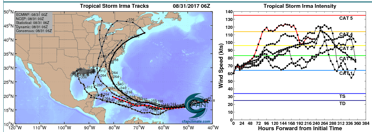
The individual runs aren't gospel, at this point, obviously. But what is very interesting is that the ECMWF and GFS are forming two widely separated tracks - one toward the Gulf, the other toward the northeastern U.S. Either solution, if verified, would be catastrophic - as would be anything in between the two.

If we're still having this same conversation come Monday or Tuesday, it's probably time to start thinking about this storm a little more seriously.
 

RUtix4me

All-American
Jan 18, 2015
9,021
9,838
113
 

RU4Real

Heisman
Jul 25, 2001
50,955
30,733
0
All

All of this track terror is courtesy of the enormous ridge that's being modeled in the mid-Atlantic.

If it weakens, just a bit, this storm could wind up wit da fishes.

If not... yeah, that's gonna be a problem.
 

RU848789

Heisman
Jul 27, 2001
65,206
44,284
113
Irma has leveled off in intensity, as somewhat expected, due to marginal sea surface temps for intensification and some intrusion of dry air. Forecast is for Irma to remain as a Cat 3 storm for a few days, but then to intensify a bit by Day 4-5 to a 140 mph Cat 4 storm as it approaches the northern Leeward Islands. Going to be a close call for those islands and then the Greater Antilles (Puerto Rico, Hispaniola and Cuba, at least), but most models show Irma going north of those islands. However, that's 6+ days out, so can't rule out a hit on those islands yet.

Beyond that, last night's models show long range solutions anywhere from Florida to New England to out to sea, although I don't recall seeing any solutions from the major models going into the Caribbean, as there has been somewhat of a northward shift in the long range. But keep in mind that accuracy beyond 5 days and especially beyond 8-9 days, when it could be approaching the Bahamas/Florida is really poor. Watchful waiting is in order for the CONUS at this time.

Also, as DT/WxRisk said, do not take the GFS seriously, as it shows an unprecedented Cat 4/5 slamming the Outer Banks, which is unheard of - he makes some very good arguments as to why that's very very unlikely (including sea surface temps not being great enough to support that strong of a storm). And worrying about individual model runs 10 days out is just nuts.
 

RU4Real

Heisman
Jul 25, 2001
50,955
30,733
0
Indeed, as the Euro begins to move more toward the GFS in terms of track, the chances for a Bermuda storm increase. Bad news for Bermuda but good news for the U.S., since that track would ultimately take Irma back out into the Atlantic.
 

wheezer

Heisman
Jun 3, 2001
169,847
25,530
113
Indeed, as the Euro begins to move more toward the GFS in terms of track, the chances for a Bermuda storm increase. Bad news for Bermuda but good news for the U.S., since that track would ultimately take Irma back out into the Atlantic.
-------------
nt
 
Last edited:

RU848789

Heisman
Jul 27, 2001
65,206
44,284
113
-------------
I hear so much about the euro plots, and then have a devil of a time actually finding a graph with it.....this time, I did.....anyway, the red line is one of the euros, which would be bad news for the gulf....the heavy black line, a consensus, would be bad news for New Jersey,eventually.......

edit:....this graph was from last night, so not sure if any significant changes since then


Wheezer - please delete that graphic or at least note prominently that it's nearly 36 hours old and misleading - that's the model suite from late Wednesday night (8/31 0Z is about 8 pm, EDT on 8/30), not late last night's runs. The Euro track shifted hundreds of miles to the NE last night.
 

RU848789

Heisman
Jul 27, 2001
65,206
44,284
113
Irma has leveled off in intensity, as somewhat expected, due to marginal sea surface temps for intensification and some intrusion of dry air. Forecast is for Irma to remain as a Cat 3 storm for a few days, but then to intensify a bit by Day 4-5 to a 140 mph Cat 4 storm as it approaches the northern Leeward Islands. Going to be a close call for those islands and then the Greater Antilles (Puerto Rico, Hispaniola and Cuba, at least), but most models show Irma going north of those islands. However, that's 6+ days out, so can't rule out a hit on those islands yet.

Beyond that, last night's models show long range solutions anywhere from Florida to New England to out to sea, although I don't recall seeing any solutions from the major models going into the Caribbean, as there has been somewhat of a northward shift in the long range. But keep in mind that accuracy beyond 5 days and especially beyond 8-9 days, when it could be approaching the Bahamas/Florida is really poor. Watchful waiting is in order for the CONUS at this time.

Also, as DT/WxRisk said, do not take the GFS seriously, as it shows an unprecedented Cat 4/5 slamming the Outer Banks, which is unheard of - he makes some very good arguments as to why that's very very unlikely (including sea surface temps not being great enough to support that strong of a storm). And worrying about individual model runs 10 days out is just nuts.
DT/WxRisk, just made a great post comparing last night's GFS and Euro.


wheezer

Heisman
Jun 3, 2001
169,847
25,530
113
Wheezer - please delete that graphic or at least note prominently that it's nearly 36 hours old and misleading - that's the model suite from late Wednesday night (8/31 0Z is about 8 pm, EDT on 8/30), not late last night's runs. The Euro track shifted hundreds of miles to the NE last night.
---
ok, will do....thought it was last night, to which I edited, but if even earlier, will remove
 

RU848789

Heisman
Jul 27, 2001
65,206
44,284
113

With it not expected to be around PR until Wed AM, when would it be in the NJ area at the earliest?

The earliest Irma could be in our area, in the unlikely event it makes it to our area, is around the 11th or 12th of September.
 

RU848789

Heisman
Jul 27, 2001
65,206
44,284
113
Irma back up to Cat 3 with 120 mph winds. 12Z GFS no longer shows a bomb hitting the OBX. It's now showing a Cat 1/2 hit to Cape Cod, then Maine/Canada. 12Z Euro moved a bit SW of last night's run and has the storm a couple of hundred miles off the coast of Jacksonville, FL, as a likely Cat 5 (model only goes out 10 days). CMC looks very similar to the Euro (also only goes 10 days).

These are going to change significantly over the next few days, as they always do this far out. More interesting is that none of the models now shows the storm heading into the Caribbean and most of the model runs (and the ensemble members) show the storm moving north of PR towards the Bahamas with divergences from there, with FL to Canada to out to sea all still on the table. So, we watch and wait.

Going to be a close call for the northernmost Leeward Islands (e.g. the Virgin Islands), although the storm is more likely than not to slide by to the north of those islands (but with some impacts almost a given). If I were iin the Bahamas, I'd start to worry a bit, as the storm could get there in about 7 days. Will take 9-10 to reach Florida, if it goes that route and 12 or more to reach NC and north, if it goes that route. Threading the needle between the east coast and Bermuda is a growing possibility, too.


http://www.nhc.noaa.gov/graphics_at1.shtml?cone#contents

https://www.americanwx.com/bb/topic/50217-major-hurricane-irma/?page=28
 

sport2231

Heisman
Jan 16, 2007
50,162
19,534
111
Just showing this for showing sake. Will change 20 more times over next 10 days but the American Model just came in with this


RU848789

Heisman
Jul 27, 2001
65,206
44,284
113
Since people are interested, last night's model runs generally show a potential landfall anywhere from Florida to New England, but also show that recurvature out to sea (but not too far from the coast) is definitely still in play. In the Day 10-11 range, the GFS is a direct hit on the DelMarVa/South Jersey (Cat 2 or so), the Euro slams SC (Charleston area; probably Cat 4), and the CMC stays ~200 miles off shore of the Outer Banks. Still pretty big uncertainties, but a landfalling US hurricane is becoming a significant risk at this point.

https://www.americanwx.com/bb/topic/50217-major-hurricane-irma/?page=40
 

Goku

All-Conference
Jul 25, 2001
8,530
1,469
0
thanks for the updates. I check all of your posts more than I check the weather channel!
 

RU848789

Heisman
Jul 27, 2001
65,206
44,284
113
thanks for the updates. I check all of your posts more than I check the weather channel!
Thanks, although I have to give TWC props. Over the past few years, they've improved their meteorologist stable immensely, especially on tropical systems with former NHC director, Rick Knabb, and tropical system expert, Bryan Norcross (famous for his 23 hour marathon live coverage of Andrew from Miami), both on staff, as well as several other very good mets. They did a wonderful job on Harvey and have been all over Irma, including what I think is judicious discussion of Irma's potential for a US landfall.
 
  • Like
Reactions: Goku

RU4Real

Heisman
Jul 25, 2001
50,955
30,733
0
The trend has been north / east. How many times do we say "the trend is your friend"? Given how far out this storm is, it wouldn't surprise me if the trend continues to move towards an OTS solution.
 

29PAS

All-Conference
Sep 21, 2001
3,428
1,394
113
I always appreciate the updates, especially now.

8 of us, mostly RU grads, have a house in Emerald Isle, NC for a week starting 9/9 and we're very concerned. We do, however, have trip insurance. Oddly enough, in 25 yrs of going there, we've only been cancelled by a hurricane once - in July!
 

RU848789

Heisman
Jul 27, 2001
65,206
44,284
113
I always appreciate the updates, especially now.

8 of us, mostly RU grads, have a house in Emerald Isle, NC for a week starting 9/9 and we're very concerned. We do, however, have trip insurance. Oddly enough, in 25 yrs of going there, we've only been cancelled by a hurricane once - in July!

I assume you've seen this graphic before, no? Can't pick a worse time, hurricane-wise to be at the OBX than around 9/10, climatologically speaking. I will say this, in all seriousness: Irma does have some potential for a direct hit on the OBX, so definitely pay attention this week - we should know pretty well where it's headed by about Thursday or Friday.


29PAS

All-Conference
Sep 21, 2001
3,428
1,394
113
Yea, we do know it's the sweet spot for storm potential and I appreciate the concern. Except for this year and last, we've always gone in July - other circumstances made us change and we'll probably go back to the former dates next year. Meanwhile, we're all watching this very closely and will follow the updates here.
 

RU848789

Heisman
Jul 27, 2001
65,206
44,284
113
Since people are interested, last night's model runs generally show a potential landfall anywhere from Florida to New England, but also show that recurvature out to sea (but not too far from the coast) is definitely still in play. In the Day 10-11 range, the GFS is a direct hit on the DelMarVa/South Jersey (Cat 2 or so), the Euro slams SC (Charleston area; probably Cat 4), and the CMC stays ~200 miles off shore of the Outer Banks. Still pretty big uncertainties, but a landfalling US hurricane is becoming a significant risk at this point.

https://www.americanwx.com/bb/topic/50217-major-hurricane-irma/?page=40

And this afternoon's model runs (including the operational global models and their ensemble runs) continue to show that anything from Florida to Maine to out to sea are on the table. GFS and Canadian both show a Chesapeake Bay hit of a Cat 2/3, while the Euro now shows an out to sea solution, 300 miles off the NJ coast. These fluctuations in the models at Days 9+ are absolutely to be expected, which is why people shouldn't get caught up in a specific solution and whether it's good or bad for anyone in particular.
 

RU4Real

Heisman
Jul 25, 2001
50,955
30,733
0
And this afternoon's model runs (including the operational global models and their ensemble runs) continue to show that anything from Florida to Maine to out to sea are on the table. GFS and Canadian both show a Chesapeake Bay hit of a Cat 2/3, while the Euro now shows an out to sea solution, 300 miles off the NJ coast. These fluctuations in the models at Days 9+ are absolutely to be expected, which is why people shouldn't get caught up in a specific solution and whether it's good or bad for anyone in particular.

Other than to keep in mind that the vast majority of CV hurricanes wind up wit da fishes.
 

RU848789

Heisman
Jul 27, 2001
65,206
44,284
113
Other than to keep in mind that the vast majority of CV hurricanes wind up wit da fishes.

True, especially for storms that track north of Puerto Rico...unfortunately past performance is no guarantee...although that's the way to bet...
 

RU4Real

Heisman
Jul 25, 2001
50,955
30,733
0
True, especially for storms that track north of Puerto Rico...unfortunately past performance is no guarantee...although that's the way to bet...

After decades of watching hurricanes, I've come to analogize CV storms - and their associated modeling - to the minute hand on a clock as it ticks its way through the bottom half of the hour. The solutions tend to rotate around the compass in a clockwise direction, starting out with "Keys / GoM", ticking their way up the coast and finally winding up in the Maritimes.

Of course, there are occasional exceptions that do actually wind up somewhere along the Atlantic coast, and some of them have been truly memorable storms. But for the most part, they just kinda make their way.

Frankly, I could do without this one.
 
  • Like
Reactions: Goku and bac2therac

Plum Street

Heisman
Jun 21, 2009
27,306
23,009
0
After decades of watching hurricanes, I've come to analogize CV storms - and their associated modeling - to the minute hand on a clock as it ticks its way through the bottom half of the hour. The solutions tend to rotate around the compass in a clockwise direction, starting out with "Keys / GoM", ticking their way up the coast and finally winding up in the Maritimes.

Of course, there are occasional exceptions that do actually wind up somewhere along the Atlantic coast, and some of them have been truly memorable storms. But for the most part, they just kinda make their way.

Frankly, I could do without this one.


I hope you're right. We can all do without this one . Then there is another one behind it to focus on
 

RU848789

Heisman
Jul 27, 2001
65,206
44,284
113
And this afternoon's model runs (including the operational global models and their ensemble runs) continue to show that anything from Florida to Maine to out to sea are on the table. GFS and Canadian both show a Chesapeake Bay hit of a Cat 2/3, while the Euro now shows an out to sea solution, 300 miles off the NJ coast. These fluctuations in the models at Days 9+ are absolutely to be expected, which is why people shouldn't get caught up in a specific solution and whether it's good or bad for anyone in particular.

And tonight's model runs once again illustrate the futility of trying to use models beyond 8-9 days for anything other than a very broad idea that Irma could make landfall between Florida and the Canadian Maritimes, with no landfall at all still possible, i.e., Irma staying offshore. Tonight's CMC crushes the east coast of Florida in multiple locations, while the GFS and Euro both hammer Wilmington, NC. All three are major hits for the northeastern Bahamas and all 3 also have major impacts for hundreds of miles inland of landfall. While these models all show a landfalling east coast hurricane, that's not a given yet, as the error bars around forecasts this far out are still quite large and up the coast, but off the coast, is still possible.
 

RUonBrain

All-American
Apr 29, 2002
8,095
7,531
113
Any chance it impacts the RU - Eastern Michigan game, or no chance it reaches NJ by then?
 

RU4Real

Heisman
Jul 25, 2001
50,955
30,733
0
Any chance it impacts the RU - Eastern Michigan game, or no chance it reaches NJ by then?

No chance. If it were coming here, it would be in the Monday range.

The (for now) agreement between the ECM and GFS should give pause to those interests along the NC coast. A few more runs with that level of consistency and I think we'll be close to knowing what this one's gonna do.
 
  • Like
Reactions: RUonBrain

RU848789

Heisman
Jul 27, 2001
65,206
44,284
113
True, especially for storms that track north of Puerto Rico...unfortunately past performance is no guarantee...although that's the way to bet...

Actually, my apologies, but this statement is incorrect. I had read something to that effect, but hadn't verified it and bluewave on AmericanWx just posted this, at least about post-1995 systems (also Hugo clipped PR in 1989 and we all know it crushed Charleston):

"The 6 hurricanes since 1995 that passed near or north of Puerto Rico and continued WNW were...

Irene...2011...Earl...2010...Jeanne...2004...Frances...2004...Geroges...1998...Bertha 1996. So this may be the first set of model runs that is close to this active phase track climo. We'll see if this general theme holds in the coming days."