Didn't see a thread and I will say the tropical threads always seemed to be very well received by posters who either are in harm's way or know people who are, so here you go.
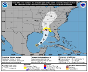
Anyway, Tropical Storm Isaias is up to 65 mph and will likely be a Cat 1 hurricane with the 11 pm NHC update. The most recent update and model consensus has the storm reaching strong Cat 2 status (up to 110 mph) before landfall, although intensity remains the most difficult parameter to forecast accurately meaning the storm could easily be significantly weaker (due to shear) or somewhat stronger (if less shear - maybe Cat 3 with 120+ mph winds). The track forecast (usually much more accurate than intensity forecasts) has Isaias making landfall somewhere between the MS coast and the western FL panhandle sometime late Friday night to very early Sat morning.
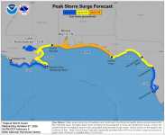
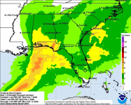
Obviously, wind damage from the hurricane and likely some tornadoes on the eastern side of the track could be significant, but storm surge may be the most dangerous element of this storm with widespread surges between 5-7 feet, as per the graphic below. Inland flooding will also likely be an issue with widespread 4-8" rainfall amounts over a large area of the central Gulf Coast, with localized amounts up to 12" likely. Eventually the storm will dissipate, but will likely result in some heavy rains (1-2"?) in our area on Sunday.
Note that this will be the first hurricane in the Atlantic Basin this season – and the latest first hurricane of the season during the satellite era (since the mid-60s); there were two earlier seasons without any hurricanes. None of this is a surprise, as every expert out there, including CSU, NOAA and more, have been calling for a well below normal season since it became obvious we'd have a strong El Nino (abnormally warm water in the equatorial Pacific) by July and we now have a record El Nino, which almost always leads to high shear downstream of the warm water, i.e., across the Caribbean and SW Atlantic and shear is the enemy of tropical system formation. The strong El Nino is also significantly responsible for the near record high level of tropical activity in the Pacific.
https://www.nhc.noaa.gov/.../graphics_at4.../072354.shtml...
FORECAST POSITIONS AND MAX WINDS
INIT 07/2100Z 22.7N 92.9W 55 KT 65 MPH
12H 08/0600Z 23.1N 91.8W 70 KT 80 MPH
24H 08/1800Z 24.1N 90.1W 80 KT 90 MPH
36H 09/0600Z 25.8N 88.7W 90 KT 105 MPH
48H 09/1800Z 28.1N 87.6W 95 KT 110 MPH
60H 10/0600Z 31.0N 87.3W 60 KT 70 MPH...INLAND
72H 10/1800Z 34.0N 87.5W 30 KT 35 MPH...POST-TROP/INLAND
96H 11/1800Z 37.5N 84.5W 15 KT 15 MPH...POST-TROP/INLAND
120H 12/1800Z...DISSIPATED
Anyway, Tropical Storm Isaias is up to 65 mph and will likely be a Cat 1 hurricane with the 11 pm NHC update. The most recent update and model consensus has the storm reaching strong Cat 2 status (up to 110 mph) before landfall, although intensity remains the most difficult parameter to forecast accurately meaning the storm could easily be significantly weaker (due to shear) or somewhat stronger (if less shear - maybe Cat 3 with 120+ mph winds). The track forecast (usually much more accurate than intensity forecasts) has Isaias making landfall somewhere between the MS coast and the western FL panhandle sometime late Friday night to very early Sat morning.
Obviously, wind damage from the hurricane and likely some tornadoes on the eastern side of the track could be significant, but storm surge may be the most dangerous element of this storm with widespread surges between 5-7 feet, as per the graphic below. Inland flooding will also likely be an issue with widespread 4-8" rainfall amounts over a large area of the central Gulf Coast, with localized amounts up to 12" likely. Eventually the storm will dissipate, but will likely result in some heavy rains (1-2"?) in our area on Sunday.
Note that this will be the first hurricane in the Atlantic Basin this season – and the latest first hurricane of the season during the satellite era (since the mid-60s); there were two earlier seasons without any hurricanes. None of this is a surprise, as every expert out there, including CSU, NOAA and more, have been calling for a well below normal season since it became obvious we'd have a strong El Nino (abnormally warm water in the equatorial Pacific) by July and we now have a record El Nino, which almost always leads to high shear downstream of the warm water, i.e., across the Caribbean and SW Atlantic and shear is the enemy of tropical system formation. The strong El Nino is also significantly responsible for the near record high level of tropical activity in the Pacific.
https://www.nhc.noaa.gov/.../graphics_at4.../072354.shtml...
FORECAST POSITIONS AND MAX WINDS
INIT 07/2100Z 22.7N 92.9W 55 KT 65 MPH
12H 08/0600Z 23.1N 91.8W 70 KT 80 MPH
24H 08/1800Z 24.1N 90.1W 80 KT 90 MPH
36H 09/0600Z 25.8N 88.7W 90 KT 105 MPH
48H 09/1800Z 28.1N 87.6W 95 KT 110 MPH
60H 10/0600Z 31.0N 87.3W 60 KT 70 MPH...INLAND
72H 10/1800Z 34.0N 87.5W 30 KT 35 MPH...POST-TROP/INLAND
96H 11/1800Z 37.5N 84.5W 15 KT 15 MPH...POST-TROP/INLAND
120H 12/1800Z...DISSIPATED