I don't post much on weather threads (or many other threads for that matter) but I do follow them and this has been the best weather thread in the years I've followed: lots of good model summaries/updates, good explanations and analysis, great reports from poster locations, and virtually no divisive bickering (shout out especially to #s and Bac!)Congrats and thanks to all! Here in Pway, beginning to accumulate on grass and north facing brick but not yet on pavement or north facing brick. Made pizza dough Friday and sauce today and will spend the balance enjoying good food and drink, listening to music, playing guitar, and hoping the storm under performs (sorry #s and other snow lovers--i love snow till Christmas but then I'm ready for spring.)
OT: Weekend snowstorm - historic blizzzard
- Thread starter Mikemarc
- Start date
You are using an out of date browser. It may not display this or other websites correctly.
You should upgrade or use an alternative browser.
You should upgrade or use an alternative browser.

The Arctic and Antarctica.
Look at the bright side! You will have more time to make posts critical of RU basketballI guess I should cancel my tee time for Monday?

last NAM run that matters at this point....18z
6-12nw nj 12-18 north jersey through somerset and 18-24 along 95 and southeast and dollop of 28-34 near the coast
that lines up somewhat with mt holly aggressive snowfall map although cuts a bit for western sections and philly

6-12nw nj 12-18 north jersey through somerset and 18-24 along 95 and southeast and dollop of 28-34 near the coast
that lines up somewhat with mt holly aggressive snowfall map although cuts a bit for western sections and philly


even more aggressive than Mt holly
3K nam
7-12 NW NJ
12-16 central jersey
16-20 amounts of confined to momouth ocean and the coast

7-12 NW NJ
12-16 central jersey
16-20 amounts of confined to momouth ocean and the coast
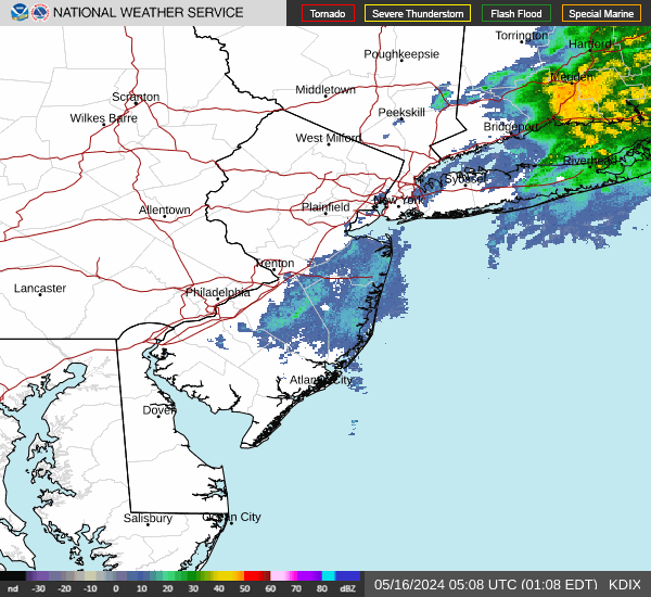
COD-NEXLAB : Dual-Pol Radar for DOX
Dual-Pol NEXRAD Data for provided by College of DuPage Meteorology (NEXLAB)
 weather.cod.edu

after 2 hours of light snow, the snow has begun to stick to the coldest surfaces only
33 degrees
33 degrees
Hey for two years I didn't start up that brand new Arien's. See what happens when I finally do. This winter all hell broke loose.Our snowblower is exactly 4 inches from the garage door, and I have left it running, so it growls like a snow watch dog. I hope we don't die from carbon monoxide poisoning.
--That was a joke---I have done stupider things than what I said above, and I have lived.
Yup coast.you are at the coast right? yeah you are doomed probably
Bring it, I say.
As a result, I blocked Tomer on X. I'm too triggered.even more aggressive than Mt holly

Fantastic discussion from the NWS-NYC detailing well why they have higher snowfall amounts than many of the models (and this applies to NWS-Philly, too, but these guys said it better). Biggest reason is snow ratios >10:1, which is what I've been talking about for awhile and just posted about above. We'll see how this plays out, but a ratio of 13:1 makes 13" of 10:1 snow 17" and makes 20" of 10:1 snow into 26" of snow. If one takes the latest 10:1 18Z HRRR and applies a 13:1 ratio to it (not Kuchera) one gets close to the current NWS map.

Area Forecast Discussion
National Weather Service New York NY
215 PM EST Sun Feb 22 2026
A potent upper level shortwave can be seen digging down towards the
southeast coast on latest water vapor satellite imagery. Out ahead
of it, surface cyclogenesis is underway and right on track off the
Mid-Atlantic coast as seen in latest surface obs and even on visible
satellite. While little wobbles in track/qpf trends were seen
in some 12z guidance, there is still excellent agreement on this
low rapidly intensifying to an impressive ~970mb central
pressure before passing somewhere near the 40N/70W benchmark
Monday morning.
While the latest 12z GFS is now lower with QPF and more in line with
the Canadian and ECMWF, these global models are struggling with
banding. Current forecast QPF and Snow Amounts remained similar
to previous forecast which is more in line with hi res/HREF
guidance. Snow amount was derived using similar snow ratios to
the previous forecast. Much of the guidance including the NBM
appears to be too high. This was mannualy adjusted down to
10:1 or even a bit lower today, then increasing to 12-14:1 by
late tonight into daybreak Monday as colder air wraps around
the system. Using these ratios with generally 1.25 to 1.50
inches of QPF across the interior and 1.75 to 2.00 inches along
the coast resulted in a swath of about 20 to 24 inches of snow
for NYC and Long Island and 16 to 20 inches elsewhere. While
this is the expected amount, a few isolated readings of 30
inches are possible in the heaviest banding, mainly along the
coast.
As for winds, the forecast remained the same for much of the
area. Out east, for eastern LI and southern New London,
confidence increased enough to bump up a few knots. There will
likely be a brief period here where a 65-70kt LLJ at 950mb will
aid in isolated 70 mph gusts at the surface.
As a general timeline for how this will play out: Light snow
will continue over the next few hours with little impact,
especially because of marginal surface temperatures. However,
conditions rapidly deteriorate this evening into tonight, with
heavy snow and 1/4 mile visibilty expected by around 7pm.
Through the night, winds will continue to increase as heavy snow
bands work through the area. White out conditions are expected
during this time resulting in traveling becoming dangerous, if
not impossible. Given latest hi res/HREF guidance and model
time heights of impressive lift in the DGZ, snowfall rates in
the heaviest bands will likely be 2 inches per hour for the
coast and 1-2 inches per hours inland. Brief rates of 3 inches
in one hour is not out of the question. Conditions start to
gradually improve Monday afternoon although winds remain gusty.
Even if we do dry out a bit earlier than forecast, blowing snow
could be an issue into Monday afternoon. Have continued to keep
mention of thunder out of the forecast but it can not be
completely ruled out along the coast late tonight into early
Monday morning.
Snow Starting to stick to streets and driveways. Looks like Game on !


What about SE of 95? I’m just busting.3K nam
7-12 NW NJ
12-16 central jersey
16-20 amounts of confined to momouth ocean and the coast
In case we start getting a lot of what will be the usual high number snow nuisance calls for Fire Department services for downed telephone wires, I gave my wife a tutorial on operating the snow blower. We have an electric start. She's an engineer like me, but she seemed intimidated by the choke and the fuel valve adjustment next to each other. I'm also not sure if she can handle the snowblower, as it is an old Toro and a beast. Normally, we are in Arizona at this time for may annual birthday celebration, and I even f'd that up- not leaving until later this week.Hey for two years I didn't start up that brand new Arien's. See what happens when I finally do. This winter all hell broke loose.
Will pay for it in summer when it’s 90+ for weeks but I’m diggin this 68-85 sunny and dry stretch here in Texas. Two days of freezing temps was quite enough.
Be safe and stay home.
Be safe and stay home.
That's St. Peter's of New Brunswick! I would also add Sacred Heart of N.B,, St. Mary's of N.B, St. Ladislaus of N.B. and St. Augustine's of Kendall Park. LOL...we would sit forever listening to WCTC for them to go through the list over and over hoping to hear our school.The following private and parochial schools are closed today
Immaculate Conception school in Edison
Immaculata High School
Jamesburg Training School for Boys
Mount Saint Marys in Watchung
St Anns in Raritan
St Ambrose
St Cecila in Edison
St Pius of New Brunswick
St Pius of Piscataway
St Thomas Aquainis
I have an Ariens with a pull and electric start engine. Why would I pull when I can just press a button lol.In case we start getting a lot of what will be the usual high number snow nuisance calls for Fire Department services for downed telephone wires, I gave my wife a tutorial on operating the snow blower. We have an electric start. She's an engineer like me, but she seemed intimidated by the choke and the fuel valve adjustment next to each other. I'm also not sure if she can handle the snowblower, as it is an old Toro and a beast. Normally, we are in Arizona at this time for may annual birthday celebration, and I even f'd that up- not leaving until later this week.
Maybe you can find a YouTube video on starting a blower similar to your model and she can reference that if she forgets. Just keep it on the lowest gear and take it easy, no need to rush.
They can be a little intimidating at first. Even I was like, I'm about to operate a huge sausage grinder and took it slow. After the 1st time of fumbling with every control known to man you pick it right up.In case we start getting a lot of what will be the usual high number snow nuisance calls for Fire Department services for downed telephone wires, I gave my wife a tutorial on operating the snow blower. We have an electric start. She's an engineer like me, but she seemed intimidated by the choke and the fuel valve adjustment next to each other. I'm also not sure if she can handle the snowblower, as it is an old Toro and a beast. Normally, we are in Arizona at this time for may annual birthday celebration, and I even f'd that up- not leaving until later this week.
So, as of 4 pm, we have 1/2" of new snow on the ground and the snow is just starting to accumulate on paved surfaces as temps are now down to 31F, so road conditions will start deteriorating quickly now.
This is ahead of the NWS schedule, which had me at 33F with rain changing to snow at 4 pm. Not sure if that's meaningful or not...

This is ahead of the NWS schedule, which had me at 33F with rain changing to snow at 4 pm. Not sure if that's meaningful or not...
Last edited:
In that generation, didn’t we all lol.That's St. Peter's of New Brunswick! I would also add Sacred Heart of N.B,, St. Mary's of N.B, St. Ladislaus of N.B. and St. Augustine's of Kendall Park. LOL...we would sit forever listening to WCTC for them to go through the list over and over hoping to hear our school.
How far north are you?So, as of 4 pm, we have 1/2" of new snow on the ground and the snow is just starting to accumulate on paved surfaces as temps are now down to 31F, so road conditions will start deteriorating quickly now.
View attachment 1196066
Snow Starting to stick to streets and driveways. Looks like Game on !
Game on here in Union county.
Yeah, same here in Howell, it's sticking good to paved surfaces now, accumulation time for all surfaces has commenced.Snow Starting to stick to streets and driveways. Looks like Game on !
I tried the pull start on my Arien's and it absolutely sucks. If I have to, I'll grab 400' of extension cords from my shop before I do that again.I have an Ariens with a pull and electric start engine. Why would I pull when I can just press a button lol.
18z RGEM fwiw the last relevant run before the storm goes in earnest
still holding as least snowiest

still holding as least snowiest
