OT: Weekend snowstorm - historic blizzzard
- Thread starter Mikemarc
- Start date
You are using an out of date browser. It may not display this or other websites correctly.
You should upgrade or use an alternative browser.
You should upgrade or use an alternative browser.
Oh ****. I jinxed it. Told kids not only no school tomorrow but probably not on Tuesday too. I’m the mush. Sorry NumbersGFS shifted east and cut totals by a decent amount. Starting to see some weenie meltdown on AmericanWx
.thumb.png.1520d76799b0ef76bc0b9666ca280f6b.png)
the RGEM has been the least snowiest model but even they have cut amounts back a bit...sort of boxing day gradient look...verbatim is 5 in nw nj moving to 8-10 in central jersey to 12-16 at coast

Got plenty of both!I'll be there at noon tomorrow, if you supply the drinks and the punk rock.
Yup just saw this. Seems the cutting back is beginning. I wonder if Mt Holly will lower there map totals. If that maps verifies it will be bust potential for the majority on NJ besides the coast.the RGEM has been the least snowiest model but even they have cut amounts back a bit...sort of boxing day gradient look...verbatim is 5 in nw nj moving to 8-10 in central jersey to 12-16 at coast
The GFS is a global model with fairly coarse resolution (25 km grid spacing, i.e., it resolves points every 25 km on the earth's surface) so like most global models is good for storm evolution/patterns, but isn't usually as good for an actual ongoing storm with numerous mesoscale features (much less than 25 km apart - think t-storms), which is why most pros only look at the mesoscale/high resolution models from this point onward. The NAM has 12km spacing and the NAM3km has 3 km grid spacing, like the HRRR. The Euro has much higher resolution than the GFS at 9 km (which is why it's usually better), but still a lot coarser than the high-res models. Most of the meso/high res models only cover the CONUS not the whole planet. Hope that helps.
Models came in hot, and now that they are older, they are falling apart with old age.
whoa Canadian really cut back,,,7-8 for many and up to 12-15 on coast...another boxing day type cutoff

Question for you and @RU848789 -- we how have 3 models cutting back. Will forecasters revise the totals if another model caves and cuts back?whoa Canadian really cut back,,,7-8 for many and up to 12-15 on coast...another boxing day type cutoff
Translation…The GFS is a global model with fairly coarse resolution (25 km grid spacing, i.e., it resolves points every 25 km on the earth's surface) so like most global models is good for storm evolution/patterns, but isn't usually as good for an actual ongoing storm with numerous mesoscale features (much less than 25 km apart - think t-storms), which is why most pros only look at the mesoscale/high resolution models from this point onward. The NAM has 12km spacing and the NAM3km has 3 km grid spacing, like the HRRR. The Euro has much higher resolution than the GFS at 9 km (which is why it's usually better), but still a lot coarser than the high-res models. Most of the meso/high res models only cover the CONUS not the whole planet. Hope that helps.
Lets pretend the weather models are different kinds of maps and cameras.


Imagine You’re Looking at a Giant LEGO World. The Earth is made of tiny LEGO squares.
Each weather model looks at the world using different-sized LEGO pieces.
 Big LEGO Blocks = GFS
- The GFS (Global Forecast System) looks at the whole planet.
- But its LEGO blocks are big — about 25 kilometers wide
- It’s great at seeing big things like:
- Hurricanes
- Large storms
- Cold fronts
- But it can’t see tiny details very well — like:
- Small thunderstorms
- Quick pop-up rain cells
- It’s like looking at your yard from an airplane. You see the big stuff… but not the ants.
 Medium LEGO Blocks = NAM (12 km)
- The NAM looks at a smaller area (mostly the U.S.).
- Its blocks are 12 km wide.
- More details than GFS
- Smaller storm features
 Tiny LEGO Blocks = NAM 3km & HRRR
- NAM 3km and HRRR use tiny 3 km blocks.
- They focus mostly on the U.S.
- Individual thunderstorms
- Small wind shifts
- Storm cells forming
That’s why meteorologists switch to these models when a storm is already happening — they need the fine detail.
 The “Euro” Model (9 km)
- The European model (often called “the Euro”) uses 9 km blocks.
- That’s much sharper than GFS.
- It still looks at most of the planet
- It’s usually better than GFS.
- But it’s still not as detailed as the 3 km models for local storms.
 Simple Summary
Big storms across the ocean? → GFS is fine.
Storm hitting right now with lots of small thunder cells? →
Pros use HRRR or NAM 3km because they can see the tiny details.
Even Shorter Version:
Big blocks = good for big weather
Small blocks = good for small, detailed weather
A Boxing Day type of outcome has always been on the table if the less-snow camp was right, although most of the models aren't showing that sharp of a cutoff to the NW. We'll see.whoa Canadian really cut back,,,7-8 for many and up to 12-15 on coast...another boxing day type cutoff

This info should be posted at top of each snowstorm thread.Translation…
Lets pretend the weather models are different kinds of maps and cameras.
Imagine You’re Looking at a Giant LEGO World. The Earth is made of tiny LEGO squares.
Each weather model looks at the world using different-sized LEGO pieces.
That means:
- The GFS (Global Forecast System) looks at the whole planet.
- But its LEGO blocks are big — about 25 kilometers wide
- It’s great at seeing big things like:
- Hurricanes
- Large storms
- Cold fronts
- But it can’t see tiny details very well — like:
- Small thunderstorms
- Quick pop-up rain cells
- It’s like looking at your yard from an airplane. You see the big stuff… but not the ants.
So it can see:
- The NAM looks at a smaller area (mostly the U.S.).
- Its blocks are 12 km wide.
It’s like looking at your neighborhood from a tall building.
- More details than GFS
- Smaller storm features
Now we’re zoomed way in. They can see:
- NAM 3km and HRRR use tiny 3 km blocks.
- They focus mostly on the U.S.
This is like standing in your yard and watching the clouds build.
- Individual thunderstorms
- Small wind shifts
- Storm cells forming
That’s why meteorologists switch to these models when a storm is already happening — they need the fine detail.
So
- The European model (often called “the Euro”) uses 9 km blocks.
- That’s much sharper than GFS.
- It still looks at most of the planet
- It’s usually better than GFS.
- But it’s still not as detailed as the 3 km models for local storms.
Big storms across the ocean? → GFS is fine.
Storm hitting right now with lots of small thunder cells? →
Pros use HRRR or NAM 3km because they can see the tiny details.
Even Shorter Version:
Big blocks = good for big weather
Small blocks = good for small, detailed weather
Where does the "Canadian" fit in here---may I speculate that the Canadian is irrelevant since they just got owned by the USA on the ice?
")

I wish. I live in a townhouse, and we aren't allowed to have them. Believe me, I've pleaded my case.I stopped praying and installed a whole house back up generator
Do you think that will happen? Could this be a bust for the western part of NJ? Euro runs in a few hours I guess that will be telling as to what happensA Boxing Day type of outcome has always been on the table if the less-snow camp was right, although most of the models aren't showing that sharp of a cutoff to the NW. We'll see.
View attachment 1195637
Bac - Just got back from field hockey practice with the little one. It’s 37 degrees, steady rain, nice snow melt of the remaining plow piles so far this morning.whoa Canadian really cut back,,,7-8 for many and up to 12-15 on coast...another boxing day type cutoff
Can you tell them no school the whole week lol.Oh ****. I jinxed it. Told kids not only no school tomorrow but probably not on Tuesday too. I’m the mush. Sorry Numbers
Board jinxers are welcome to pull out all the stops.
Sign me up for the 5.4inch snowfall in and around Philadelphia!!whoa Canadian really cut back,,,7-8 for many and up to 12-15 on coast...another boxing day type cutoff
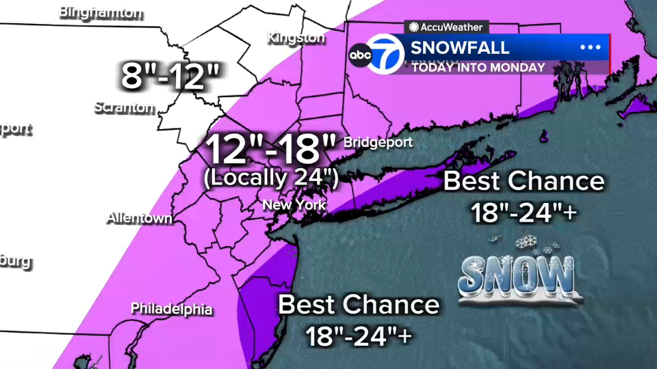
I think we'll have more NW of 95 than we had for 12/26/10, but I do think those 12-18" amounts for NW areas could easily be 8-12" and the 18-24" amounts for 95 could easily be 12-20"; the coast is still very likely to be >20". But the high res models are mostly still showing pretty big snow. Tough call and I'm not qualified to make that call, really (not sure anyone is).Do you think that will happen? Could this be a bust for the western part of NJ? Euro runs in a few hours I guess that will be telling as to what happens
Tomer Burg is posting at 2 p.m. We'll see what he has to say. . . . .I think we'll have more NW of 95 than we had for 12/26/10, but I do think those 12-18" amounts for NW areas could easily be 8-12" and the 18-24" amounts for 95 could easily be 12-20"; the coast is still very likely to be >20". But the high res models are mostly still showing pretty big snow. Tough call and I'm not qualified to make that call, really (not sure anyone is).
Ukie is 8 in NW to 12 in central jersey to 16 at coast,,,might be the winner
Question for you and @RU848789 -- we how have 3 models cutting back. Will forecasters revise the totals if another model caves and cuts back?
Mt holly is usually hard headed...I think they went over their skis for PA and I think that is where they might reduce but for NJ especially the coast I dont see a change. I think the issue is with banding you dont know where it sets up so we could have only 12 in belle mead 16 in Metuchen and 22 in Toms River....I think their low end should have stressed more....but I think they just wanted to paint a broad brushQuestion for you and @RU848789 -- we how have 3 models cutting back. Will forecasters revise the totals if another model caves and cuts back?
they HEAVILY rely on NBM and when you have the nam putting out ridiculous totals well its always going to get skewed
Would be a nice storm, but no where close to historic as the wishcasters were pumping for the past several days.Ukie is 8 in NW to 12 in central jersey to 16 at coast,,,might be the winner
yeah I dont see it being that intense of a gradient but I can see the same cut off zonesA Boxing Day type of outcome has always been on the table if the less-snow camp was right, although most of the models aren't showing that sharp of a cutoff to the NW. We'll see.
View attachment 1195637
I don’t think we get the 20 inches etc.
I think it ll be like 10-12 inches for Monmouth county.
Just a gut opinion - nothing based on science / meteorology etc.
I think it ll be like 10-12 inches for Monmouth county.
Just a gut opinion - nothing based on science / meteorology etc.
Right now, for my locale, 3 miles west of Manasquan Beach, they haveMt holly is usually hard headed...I think they went over their skis for PA and I think that is where they might reduce but for NJ especially the coast I dont see a change. I think the issue is with banding you dont know where it sets up so we could have only 12 in belle mead 16 in Metuchen and 22 in Toms River....I think their low end should have stressed more....but I think they just wanted to paint a broad brush
they HEAVILY rely on NBM and when you have the nam putting out ridiculous totals well its always going to get skewed
2-4 inches today, 16-22 tonight, and 4-8 tomorrow-that's a total range of 22-34 inches. That's wild. What's a bust in this scenario?--I say anything less than 15 inches is a bust
Do you understand how the board jinx works?I don’t think we get the 20 inches etc.
I think it ll be like 10-12 inches for Monmouth county.
Just a gut opinion - nothing based on science / meteorology etc.
I think 36 inches plus is possible in Monmouth, particularly near the coast!
the Canadian is a global but the Reggie RGEM is a short term high resolution modelThis info should be posted at top of each snowstorm thread.
Where does the "Canadian" fit in here---may I speculate that the Canadian is irrelevant since they just got owned by the USA on the ice?
Just asked my daughter to my my cars to higher ground as they are predicting major flooding with the snow in OCNJ. Praying for a bust
36 here..wind picking up with some light rainBac - Just got back from field hockey practice with the little one. It’s 37 degrees, steady rain, nice snow melt of the remaining plow piles so far this morning.
what are your local tv mets saying..im assuming they may be different than Mt hollys 18-24Sign me up for the 5.4inch snowfall in and around Philadelphia!!
I think you guys are going to have the worst of it...i think pretty much every single model has been consistent with given you guys the worst of the storm. Even when the models earlier in the week were not biting the lean was alway to coastal nj. I think you guys are looking a foot the floor and ceiling 30 inches...but yeah if you guys get less than a foot then call it a bust. The higher amounts of 24 plus are put in there because its a decent possibility given the deepening of the low and the deformation zone setting up banding with potential for 3 inch an hour snow dumps. One thing I do know, people forget busts quickly and move on...yeah talk about it a few days but always get memoryholed.Right now, for my locale, 3 miles west of Manasquan Beach, they have
2-4 inches today, 16-22 tonight, and 4-8 tomorrow-that's a total range of 22-34 inches. That's wild. What's a bust in this scenario?--I say anything less than 15 inches is a bust
Do we know timing of 2-4" per hour? I want to get out in that.
I think I heard this evening.Do we know timing of 2-4" per hour? I want to get out in that.
ETA for the storm in Upper Somerset County? I might try getting to gym in a.m., but of course not too early lol.
My brain hurts trying to figure out your LEGO analogy. I get it you were only trying to help.Translation…
Lets pretend the weather models are different kinds of maps and cameras.
Imagine You’re Looking at a Giant LEGO World. The Earth is made of tiny LEGO squares.
Each weather model looks at the world using different-sized LEGO pieces.
That means:
- The GFS (Global Forecast System) looks at the whole planet.
- But its LEGO blocks are big — about 25 kilometers wide
- It’s great at seeing big things like:
- Hurricanes
- Large storms
- Cold fronts
- But it can’t see tiny details very well — like:
- Small thunderstorms
- Quick pop-up rain cells
- It’s like looking at your yard from an airplane. You see the big stuff… but not the ants.
So it can see:
- The NAM looks at a smaller area (mostly the U.S.).
- Its blocks are 12 km wide.
It’s like looking at your neighborhood from a tall building.
- More details than GFS
- Smaller storm features
Now we’re zoomed way in. They can see:
- NAM 3km and HRRR use tiny 3 km blocks.
- They focus mostly on the U.S.
This is like standing in your yard and watching the clouds build.
- Individual thunderstorms
- Small wind shifts
- Storm cells forming
That’s why meteorologists switch to these models when a storm is already happening — they need the fine detail.
So
- The European model (often called “the Euro”) uses 9 km blocks.
- That’s much sharper than GFS.
- It still looks at most of the planet
- It’s usually better than GFS.
- But it’s still not as detailed as the 3 km models for local storms.
Big storms across the ocean? → GFS is fine.
Storm hitting right now with lots of small thunder cells? →
Pros use HRRR or NAM 3km because they can see the tiny details.
Even Shorter Version:
Big blocks = good for big weather
Small blocks = good for small, detailed weather
Last edited:
Was busy watching Canadian tears...what's the cutback talk? Up here in Bergen the NWS has upped us from 16" as of last night to 18" this morning
What's your gut telling you RU vs Washington?I don’t think we get the 20 inches etc.
I think it ll be like 10-12 inches for Monmouth county.
Just a gut opinion - nothing based on science / meteorology etc.