See post 226 above - shouldn't be too bad probably before sunset.So what does Sunday look like for being on the roads? My weather app makes it look like a non issue until the evening, with a mix early changing to snow in the afternoon, but less then an inch. Mercer county. Wondering if a HS activity needs to end early.
OT: Weekend snowstorm - historic blizzzard
- Thread starter Mikemarc
- Start date
You are using an out of date browser. It may not display this or other websites correctly.
You should upgrade or use an alternative browser.
You should upgrade or use an alternative browser.

Nam starts midday Sunday and then starts tapering off Monday afternoon with some linger snowsTrending later and later in the day Sunday. The latest NAM has it going into Monday
Yep, some of that though is it still not being in its wheelhouse timing range, combined with how fragile the setup is, but still that's pretty bad. I fully expect a NAM run soon to show rain for coastal areas - only half joking.Nam went from 0 to 2 feet in 2 runs
Has Gov. Mikie with the long face declared State of Emergency yet?
Mt Holly starting with 6 inch plus for general area but up to 10 in their disco for the southern areas. Decent job to alert people without biting on the snowiest solutions and overdoing it.
their snow map though showing only 3-6 inches for many seems odd?

NYC showing significantly more than Mt. Holly.

Conditions will not be an issue, but airlines are odd about scheduling, especially if your flight is coming from somewhere with delays. Good luck. I suggested a few friends of mine move theirs to Saturday a few days ago even when it wasn't looking that bad, because the potential was always there and it didn't matter to them - they're very happy nowI moved by 6pm flight Sunday up to 11:30 am, hoping I can get outta town before it gets too bad.
Good luck to my wife shoveling us out Monday. I’m sure I won’t get an earful for that!
see my other posts on this - mt. holly maps weren't up to date and now they're up to date, but only through 7 am Monday, which is dumb - will be 1-3" short probably
Has Gov. Mikie with the long face declared State of Emergency yet?
would at least make sense this time! Lol

icon is half of the gfs and nam..9-15
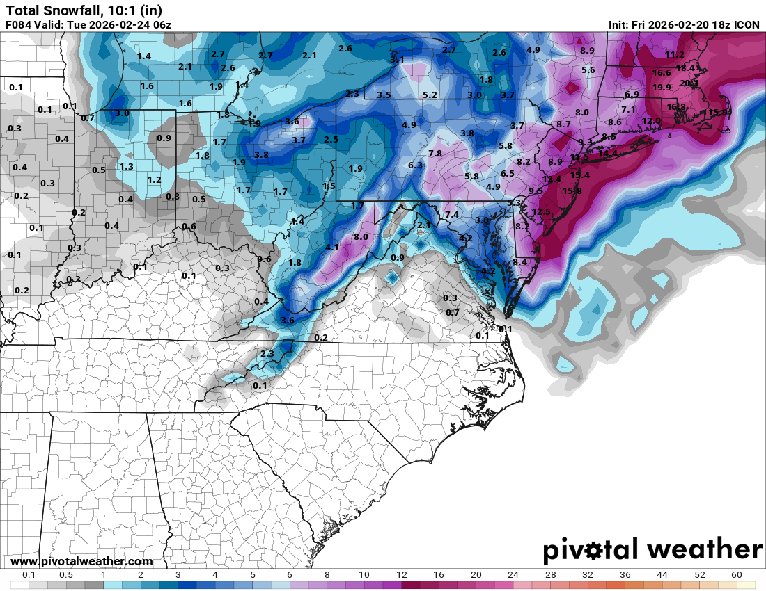
I think that’s more realistic
When are we expecting this to start in north Jersey: need to drive my youngest back to Rutgers Newark on Sunday.
still not set but most models have midday, some models have rain or wet snow not sticking with marginal temps...if it before noon in your parts you should be okay to do that with little issuesWhen are we expecting this to start in north Jersey: need to drive my youngest back to Rutgers Newark on Sunday.
My extremely amateur initial call:
10-16 Jersey shore, New York City on east
8-12 just inland in southern and central nj and ne nj
4-8 nw nj.
10-16 Jersey shore, New York City on east
8-12 just inland in southern and central nj and ne nj
4-8 nw nj.
there are definitely models that have less so just running with gfs nam solution and declaring victory isnt wise by the weenies on americanwx.I think that’s more realistic
i think we are in for some changes still and it wont be model noise as they like to say.
Could be some light snow/snow showers any time after noon, but accumulating snow probably holds off unti 4-5 pm for you. Just about any road should be fine until at least 4 pm with light intensity and daylight and probably salt.When are we expecting this to start in north Jersey: need to drive my youngest back to Rutgers Newark on Sunday.
latest GFS has a much more impactful start time verbatimCould be some light snow/snow showers any time after noon, but accumulating snow probably holds off unti 4-5 pm for you. Just about any road should be fine until at least 4 pm with light intensity and daylight and probably salt.

18Z brief comments and the NWS-Philly finally published a snow map for the whole event, below (6:45 pm edit: map is updated to include Upton counties - no changes though). The snow map is almost identical to what I was saying I would've done, being a few inches below the NBM map. They can still go up from here if warranted, but if the storm backtracks a bit (more out to sea again), they might not have to change the forecast since right now it's likely underdone a bit. I like that strategy. Also included the new map from Lee Goldberg who finally broke down and upped snowfall amounts substantially, although I think he's still on the low side a bit for 95 (I like Lee, but he was late on this one IMO), and TWC which looks pretty good to me (similar to the NWS - just a touch higher maybe).


- 18Z NAM is a monster like the GFS with 18-24" for 95/NW and 24-30" from 95 to the coast. Wow.
- 18Z ICON has 8-12" for 95/NW and 12-16" from 95 to the coast. Still pretty big.
- 18Z RGEM has 4-6" for 95/NW and 6-10" from 95 to the coast. Lowest snowfall of any model right now.
- 18Z GFS is 20-28" for the entire area. That's just nuts.
- 18Z AIGFS backed off a little with 8-12" NW of 95, 12-18" for 95 and 18-22" towards the coast (2-3" decrease)
- 18Z Euro-AIFS is 8-10" NW of 95, 10-15" for 95 and 15-20" towards the coast (a 3-4" increase from 12Z)
- 18Z Euro shows 5-7" NW of 95, 7-10" for 95 and 10-12" towards the coast (a 2-4" increase)
- The Euro is no longer the least snowy model, which is big as many forecasters have held back on bigger numbers over concerns that the Euro wasn't on board (and is the best model, historically). I could see forecasts going up a few inches across the board later tonight if 0Z looks fairly similar.
Attachments
-
 1771623557880.png1.1 MB · Views: 6
Last edited:

Cross Country skiis may be needed. Not that far for you.When are we expecting this to start in north Jersey: need to drive my youngest back to Rutgers Newark on Sunday.

EPA weather going hard


Weather Alerts
There are no current/valid alert products Last updated: 3:00 PM Wednesday March 4th, 2026 Overview: Storm impact level and timing: Snow impacts: Snow consistency: Ice impacts: Rain impacts: Wind impacts: Travel disruptions: Power outage concerns: School cancellations/delays: For more...
epawaweather.com
After catching up on this thread today, all I can say is this f’ing sucks!
Going to be 36 on Sunday and Monday and 40-50 for the rest of the week. Massive bust potential for this storm.EPA weather going hard
Weather Alerts
There are no current/valid alert products Last updated: 3:00 PM Wednesday March 4th, 2026 Overview: Storm impact level and timing: Snow impacts: Snow consistency: Ice impacts: Rain impacts: Wind impacts: Travel disruptions: Power outage concerns: School cancellations/delays: For more...epawaweather.com
SheeshEPA weather going hard
Weather Alerts
There are no current/valid alert products Last updated: 3:00 PM Wednesday March 4th, 2026 Overview: Storm impact level and timing: Snow impacts: Snow consistency: Ice impacts: Rain impacts: Wind impacts: Travel disruptions: Power outage concerns: School cancellations/delays: For more...epawaweather.com
She established a hotline for reporting ice already.would at least make sense this time! Lol


Good. As the song goes, “You plant ice you gonna harvest wind”.She established a hotline for reporting ice already.
Had quite the scary ice situation as the last storm melted off our low pitch roof with solar panels. The sheets of ice were hanging off the gutter line by a few feet and would not budge. This was right over our garage entrance. After we pulled into the garage, an avalanche ensued, and we had quite the pile of snow and ice chunks blocking us in.Good. As the song goes, “You plant ice you gonna harvest wind”.
This is the Asbury Park Press current headline- reminding me of winter when I was a kid:
Oh no, not again: Heavy, ‘plowable snow’ to hit NJ Shore this weekend
