Down to 916 mbar pressure (27.05" of mercury), but they kept the winds at 185 mph, despite 192 mph winds at 914 mbar (about 75 feet up). Weenies arguing it should've been 190 mph, tying Allen for the all-time Atlantic Basin hurricane wind speed record.
OT: Official Hurricane Irma Thread
- Thread starter RU4Real
- Start date
You are using an out of date browser. It may not display this or other websites correctly.
You should upgrade or use an alternative browser.
You should upgrade or use an alternative browser.
Italy is almost certainly to get missed by this hurricane. You should be safe. Review your emergency check list anyway - can be too safe. Salut!
Mods - delete this banter post, please. Oh wait, our whole board is banter posts. Never mind.
Down to 916 mbar pressure (27.05" of mercury), but they kept the winds at 185 mph, despite 192 mph winds at 914 mbar (about 75 feet up). Weenies arguing it should've been 190 mph, tying Allen for the all-time Atlantic Basin hurricane wind speed record.
Worth noting that the AF recon plane measured a 226 mph wind about 600' off the ground. This storm is crazy intense.
Also, Anguilla is about to get hit full-on. That strikes a personal chord for me because it's my favorite resort destination. The beaches are beautiful, the people are the most friendly folks in the Caribbean and there are a couple of very nice, high-end resorts that should be on anybody's travel "to do" list. I wish them well.
First of all, thank you all for this thread. It is my go to. I am in Jacksonville and where I live got hit hard by Matthew. Lots of flooding so this one has me concerned. I don't live in a flood zone however where I live in St John's county has been building so fast I am not suprised the water has no where to go.
As I understand it the wind speed is not the only measurement to be worried about. Looks like this is slow moving with some staying power. Any opinions on that.
Thnx.
Hey! I'm just trying to help.Mods - delete this banter post, please. Oh wait, our whole board is banter posts. Never mind.

What are the odds my condos in trouble in Perdido Key Fl (Alabama line)
At this time, your condo has a better chance of winning the lottery than taking Irma head-on. This could, of course, change. So stay tuned.
First of all, thank you all for this thread. It is my go to. I am in Jacksonville and where I live got hit hard by Matthew. Lots of flooding so this one has me concerned. I don't live in a flood zone however where I live in St John's county has been building so fast I am not suprised the water has no where to go.
As I understand it the wind speed is not the only measurement to be worried about. Looks like this is slow moving with some staying power. Any opinions on that.
Thnx.
Right now Irma doesn't have much room to grow in terms of intensity. There are theoretical limits that define the upper ends of cyclone potential. Irma, right now, is very close to the all-time records for pressure and wind speed.
Where she does have room to grow is with regard to... well, growing. She can get bigger. The radius of hurricane force winds can expand, as can the radius of tropical storm force winds. There's a lot of reason to believe that if Irma avoids any significant interaction with the Cuban landmass, this will happen.
Hope your right, Mr G had a model going to the gulf up Fl west coast Will def stay tunedAt this time, your condo has a better chance of winning the lottery than taking Irma head-on. This could, of course, change. So stay tuned.
Right now Irma doesn't have much room to grow in terms of intensity. There are theoretical limits that define the upper ends of cyclone potential. Irma, right now, is very close to the all-time records for pressure and wind speed.
Where she does have room to grow is with regard to... well, growing. She can get bigger. The radius of hurricane force winds can expand, as can the radius of tropical storm force winds. There's a lot of reason to believe that if Irma avoids any significant interaction with the Cuban landmass, this will happen.
Last edited:
Hope your right, Mr G had a model going to the gulf up Fl west coast
That was a single member of an ensemble. Kinda like rolling 100 pair of dice then pointing to one roll and saying, "Look! See? Snake eyes."
I thought the pressure wasn't all that low, at least for a Cat 5. And if the pressure were to drop more, it might mean higher winds, but it could possibly lead to a larger storm. At least that is what I am gathering watching TWC.At this time, your condo has a better chance of winning the lottery than taking Irma head-on. This could, of course, change. So stay tuned.
Right now Irma doesn't have much room to grow in terms of intensity. There are theoretical limits that define the upper ends of cyclone potential. Irma, right now, is very close to the all-time records for pressure and wind speed.
Where she does have room to grow is with regard to... well, growing. She can get bigger. The radius of hurricane force winds can expand, as can the radius of tropical storm force winds. There's a lot of reason to believe that if Irma avoids any significant interaction with the Cuban landmass, this will happen.
I thought the pressure wasn't all that low, at least for a Cat 5. And if the pressure were to drop more, it might mean higher winds, but it could possibly lead to a larger storm. At least that is what I am gathering watching TWC.
There have been pressures measured as low as 924 mb - you're right, there's some room for Irma to go lower, but probably no lower than 900. The relationship between pressure and wind speed isn't always linear and with measured sea level winds approaching 195 mph in some spots it's more reasonable to believe that Irma has much more potential with regard to size, rather than intensity.
4Real and/or Numbers,
I live in Mount Pleasant, SC just outside of Charleston. What's your best guess at this time for the impact to the Lowcountry? This looks like it could skirt up the coast like Matthew last year. Just curious as to your best guess at this point in time.
Thanks!
I live in Mount Pleasant, SC just outside of Charleston. What's your best guess at this time for the impact to the Lowcountry? This looks like it could skirt up the coast like Matthew last year. Just curious as to your best guess at this point in time.
Thanks!
Wind speeds are a mixture of low pressure and size of storm. A smaller storm with pressure of X will have higher winds then a larger storm with the same pressure.There have been pressures measured as low as 924 mb - you're right, there's some room for Irma to go lower, but probably no lower than 900. The relationship between pressure and wind speed isn't always linear and with measured sea level winds approaching 195 mph in some spots it's more reasonable to believe that Irma has much more potential with regard to size, rather than intensity.
This storm is not necessarily large, nor does it have a super low pressure, but it has extremely high winds. So it has the mixture.
4Real and/or Numbers,
I live in Mount Pleasant, SC just outside of Charleston. What's your best guess at this time for the impact to the Lowcountry? This looks like it could skirt up the coast like Matthew last year. Just curious as to your best guess at this point in time.
Thanks!
The 18z GFS is the model run that does you wrong.
It's got you feeling Cat 1 winds around 8am with a landfall near Savannah about 12 hours later.
As we said earlier, it's one run of one model, but you should definitely be paying attention, as a number of pros feel like the GA/SC solution that the Euro has hinted at for the last 24 hours is the most likely scenario.
Wind speeds are a mixture of low pressure and size of storm. A smaller storm with pressure of X will have higher winds then a larger storm with the same pressure.
This storm is not necessarily large, nor does it have a super low pressure, but it has extremely high winds. So it has the mixture.
Yeah. I get what makes it work. And as the storm gets larger the isobars get further apart so it requires a lower pressure to sustain a given wind velocity over a larger area. Which is what I'm saying is going to happen.
Latest spaghetti models have it more Northeast.
Chances for it to snake up the coast to NJ just increased.
Chances for it to snake up the coast to NJ just increased.
Latest spaghetti models have it more Northeast.
Chances for it to snake up the coast to NJ just increased.
See the whole board.
It's just not likely, as there's no atmospheric support for that.
What are the odds my condos in trouble in Perdido Key Fl (Alabama line)
Suggest that those in Perdido Key, FL head to the Flora-Bama Lounge and Oyster Bar and hunker down till the storm passes through.
Suggest that those in Perdido Key, FL head to the Flora-Bama Lounge and Oyster Bar and hunker down till the storm passes through.
Is there anything better than a good oyster bar? I don't think so.
Then why do models suggest it?See the whole board.
It's just not likely, as there's no atmospheric support for that.
Then why do models suggest it?
A northeast landfall? They don't.
Cause none really track out that far? but some do suggest it coming up the east side of Fl, in which case I assume it's possible?A northeast landfall? They don't.
Cause none really track out that fa? but some do suggest it coming up the east side of Fl, in which case I assume it's possible?
In the last 48 hours or so the various ensemble members have, at times, supported tracks which landfall Irma from Cape Coral, FL on the western edge to around Charlotte, SC on the eastern edge.
Regardless of the landfall point, every single operational model and ensemble member has taken Irma to the exact same place to die - the Ohio Valley. The upper atmosphere synoptics have rendered that very, very consistently.
Then why do models suggest it?
None of the 12Z models, 18Z models, nor the currently running 0Z models suggest a landfall anywhere north of NC. The models do appear to be suggesting a potential small shift in the track to the east vs. what we saw earlier today, but that may end up just being the difference between hitting the west coast of FL and hitting the east coast, not impacting the NE US with a direct landfall.
Things can easily change.
It can clip the Carolina coast and make a direct hit up north in NJ/NY.
It can clip the Carolina coast and make a direct hit up north in NJ/NY.
Ya, I mean they don't know if it's going into the gulf or up the east side of FL. So to say they know what it will do after the near term? When they don't k' know the near term? I don't know about that.Things can easily change.
It can clip the Carolina coast and make a direct hit up north in NJ/NY.
becktheory I've been in the Jacksonville area since '90. Don't know how long you've been here but until Matthew it seemed like the safest place in Florida. I'm hoping we get a pass. Unfortunately I'm heading out of town for a few days and the wife is a little pissed.First of all, thank you all for this thread. It is my go to. I am in Jacksonville and where I live got hit hard by Matthew. Lots of flooding so this one has me concerned. I don't live in a flood zone however where I live in St John's county has been building so fast I am not suprised the water has no where to go.
As I understand it the wind speed is not the only measurement to be worried about. Looks like this is slow moving with some staying power. Any opinions on that.
Thnx.
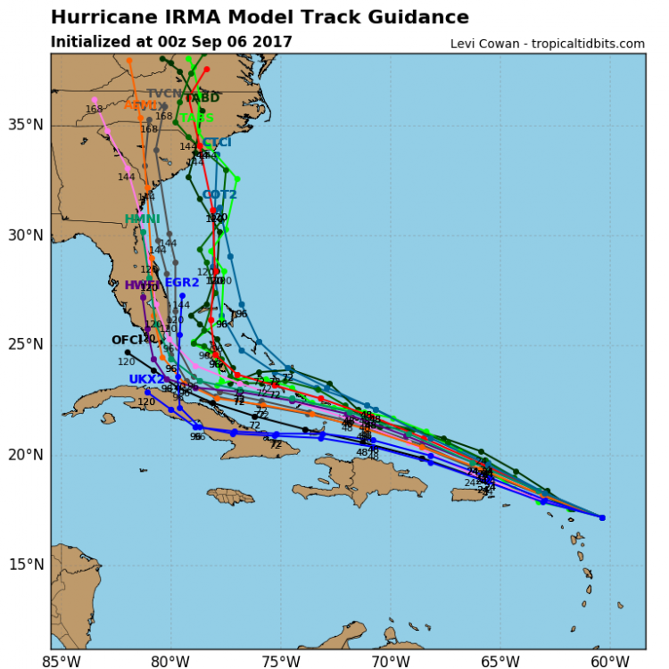
Really good video from Levi Cowan, the guy who runs Tropical Tidbits. Does a great job explaining the short term and mid term possibilities and why, in terms of steering currents/other players that could affect Irma's track/intensity. Rick Knabb on TWC, former NHC director, has also been awesome tonight. Here's my best attempt at summarizing what these guys and folks like DT are saying:
- Tonight's 0Z models should have the best initial conditions since Irma formed, as the NOAA-G4 hurricane hunter jet obtained a great data set, which will be injected into these model runs, providing a better starting point for a hopefully more accurate set of model runs.
- Irma is at 185 mph tied with several other storms for 2nd highest winds in the Atlantic Basin ever (tied with Wilma, Gilbert, and the 1935 Labor Day storm that hit the Keys - the most intense storm ever to make US landfall; Allen was first at 190 mph and Irma might reach that). Irma's 916 mbar pressure is about tenth ever in the Atlantic Basin; Wilma's 882 mbar is the record.
- Barbuda, Anguilla, and the Virgin Islands are about to get annihilated by a direct hit from an historic Cat 5 hurricane; hope people there took the proper shelter (90% of deaths in hurricanes are from storm surge and flooding, not winds).
- The North end of Puerto Rico, including San Juan, is going to be very close to the SW eyewall of Irma, but if the current track holds - and the turn to the WNW is clearly underway - Irma will likely miss PR, but still hit it with major hurricane force wind gusts, major storm surge and 10" rains.
- Irma is likely to stay north of Hispaniola and it's going to come very close to the northern coast of Cuba. If the recent trend back to the NE with the track continues, Cuba would not be hit, but the Euro and others do show a Cuba landfall, so it's going to be a close call. A prolonged path across Cuba is the one thing that could weaken Irma considerably (to maybe Cat 2/3).
- Which brings us to Florida. Since it's 5 days out, it's very hard to say what the impacts will be, since the storm is supposed to turn sharply north somewhere around that time, but knowing exactly when is impossible at this time. So Irma could head up the Florida Gulf coast, go right up the peninsula, or go right up the east coast, any of which would be catastrophic for a Cat 4/5 storm making landfall in Florida, with devastating winds, huge storm surges in areas not much above sea level, and 10-20" rains, as well as tornadoes. And even if Irma spends a lot of time crossing Florida somewhere, it won't weaken all that much.
- At this point, the furthest west we're likely to see Irma go is the Florida panhandle and the furthest east is the Carolinas (assuming it actually misses Florida), but a direct hit on Florida is at least a 50/50 chance. Out to sea, completely, has become a pretty low probability, but not zero.
- Very far out to predict what might happen north of Florida, but most models eventually bring Irma well inland of FL or the SE coast. Impacts in the NJ area are likely to be minimal, although that's still 8-10 days out. So while major impacts are very unlikely, it's always possible that the remnants of an inland storm or even a weak tropical storm could hit us (especially if it misses FL and hits the Carolinas) with heavy rains and high winds. No model shows a direct landfall in our area, like an Irene or a Sandy.
"hurricanes are famous for doing things you don't expect"
Towards the end of that video(which was an interesting watch) they showed the various euro models, and there was a wide span, some still going out into the Atlantic, but some grating the coast and effecting us here in NJ. Though granted, it would not be a direct hit.
But again, that's so long term.
Yeah. I get what makes it work. And as the storm gets larger the isobars get further apart so it requires a lower pressure to sustain a given wind velocity over a larger area. Which is what I'm saying is going to happen.
It's always the isobars that get you!
QUOTE
OK a real question. Based on how I read this it seems to imply that the models are restarted from zero each time they get data to plug into the next model run.
1. Did I read that right? Do they really discard all historic data from the storm in the model for each run?
2. Or does the model use data from earlier points in the storm and it's predictions are updated with real world measurements and the model continues to run from some point back in time. I.E.: (120, 60, 48?) hours ago + new measurements? Gotta be this, right?
Bonus Question: Do all models treat the data set the same way as sorta described above?
Seems to me that a bunch of measurement records over time would produce better results than just new initial conditions. That why it's gotta be #2 right?
See I can be a grownup too. : P
- Tonight's 0Z models should have the best initial conditions since Irma formed, as the NOAA-G4 hurricane hunter jet obtained a great data set, which will be injected into these model runs, providing a better starting point for a hopefully more accurate set of model runs.
OK a real question. Based on how I read this it seems to imply that the models are restarted from zero each time they get data to plug into the next model run.
1. Did I read that right? Do they really discard all historic data from the storm in the model for each run?
2. Or does the model use data from earlier points in the storm and it's predictions are updated with real world measurements and the model continues to run from some point back in time. I.E.: (120, 60, 48?) hours ago + new measurements? Gotta be this, right?
Bonus Question: Do all models treat the data set the same way as sorta described above?
Seems to me that a bunch of measurement records over time would produce better results than just new initial conditions. That why it's gotta be #2 right?
See I can be a grownup too. : P
QUOTE
/QUOTE
- Tonight's 0Z models should have the best initial conditions since Irma formed, as the NOAA-G4 hurricane hunter jet obtained a great data set, which will be injected into these model runs, providing a better starting point for a hopefully more accurate set of model runs.
OK a real question. Based on how I read this it seems to imply that the models are restarted from zero each time they get data to plug into the next model run.
1. Did I read that right? Do they really discard all historic data from the storm in the model for each run?
2. Or does the model use data from earlier points in the storm and it's predictions are updated with real world measurements and the model continues to run from some point back in time. I.E.: (120, 60, 48?) hours ago + new measurements? Gotta be this, right?
Bonus Question: Do all models treat the data set the same way as sorta described above?
Seems to me that a bunch of measurement records over time would produce better results than just new initial conditions. That why it's gotta be #2 right?
See I can be a grownup too. : P
Good question. Actually it's #1. In numerical modeling, the initial state is the starting point, so for global models the initial conditions, globally, are input into the models and the models then use the equations which represent the best understanding of the physics and thermodynamics of the atmosphere to try to then predict some future atmospheric state at some time step interval (usually tens of minutes) and then the predicted data from the first time step are used, along with the model to predict the global conditions at the next time step and so on.
Older data are irrelevant in this process - what is useful, though, is to compare the output from the models to the actual reality observed in the future to both provide an accuracy or verification score and to try to understand, numerically, or scientifically, what "went wrong" with the model. Usually, what is "wrong" is that there is a paucity of good global date in three dimensions for the initial conditions, combined with limitations of the partial differential equations used to describe and predict the future state - these equations cannot actually be solved analytically, so numerical methods are used to solve the equations and this introduces errors, which propagate out in time, creating larger and larger errors and uncertainties as the models run further out in time. The wiki page is actually quite a good source to help understand all of this.
https://en.wikipedia.org/wiki/Numerical_weather_prediction
So, the 11 pm NHC track has been updated, taking Irma to just about the top of the Florida Keys in 5 days. Irma could still go up the Florida west coast, the east coast or right up the peninsula - and further offshore of either coast with a FL panhandle landfall or a SC/NC landfall are still possible - and even out to sea not making US landfall is still possible. The 5 am NHC advisory should reflect model runs from tonight that have ingested a ton of great iniitial condition data for the hurricane from the hunter aircraft and from the doubling of weather balloon launches over the US.
And the GFS at 0Z still keeps Irma east of the FL coast, with a landfall around Charleston as what I guess would be a Cat 4 system at 138 hours on Monday afternoon. While the UK has landfall near Miami and the CMC has Irma missing Florida and then missing any US landfall, meandering well offshore for days, before coming close to Cape Cod. The Euro comes out shortly - thinking it comes east a bit and doesn't hit Cuba - maybe closer to the GFS.
Edit: the Euro is about 100 miles east of where it was 12 hours ago at 12Z at 120 hours, as it's just off the coast of Miami, whereas earlier today it was just about over Naples. It then stays offshore and makes landfall in SW of Charleston as a major hurricane (hard to tell if Cat 3 or 4). Huge shift and implications, as the Euro has consistently been the best model at 4-5 days. I'm sure the much more complete set of initial conditions is playing a big role here. This significant shift east in almost all of the models brings out to sea back into play as a serious possibility.
Last edited:
So, the 11 pm NHC track has been updated, taking Irma to just about the top of the Florida Keys in 5 days. Irma could still go up the Florida west coast, the east coast or right up the peninsula - and further offshore of either coast with a FL panhandle landfall or a SC/NC landfall are still possible - and even out to sea not making US landfall is still possible. The 5 am NHC advisory should reflect model runs from tonight that have ingested a ton of great iniitial condition data for the hurricane from the hunter aircraft and from the doubling of weather balloon launches over the US.
And the GFS at 0Z still keeps Irma east of the FL coast, with a landfall around Charleston as what I guess would be a Cat 4 system at 138 hours on Monday afternoon. While the UK has landfall near Miami and the CMC has Irma missing Florida and then missing any US landfall, meandering well offshore for days, before coming close to Cape Cod. The Euro comes out shortly - thinking it comes east a bit and doesn't hit Cuba - maybe closer to the GFS.
Edit: the Euro is about 100 miles east of where it was 12 hours ago at 12Z at 120 hours, as it's just off the coast of Miami, whereas earlier today it was just about over Naples. It then stays offshore and makes landfall in SW of Charleston as a major hurricane (hard to tell if Cat 3 or 4). Huge shift and implications, as the Euro has consistently been the best model at 4-5 days. I'm sure the much more complete set of initial conditions is playing a big role here. This significant shift east in almost all of the models brings out to sea back into play as a serious possibility.
What a difference a much richer set of initial conditions can make, especially the data from the recon flights. All of the experts were saying tonight's runs would incorporate much better data inputs, which should mean more accurate model output, so I'd expect to see future model runs more in line with tonight's, especially as we're now within the 5-day NHC window and the Euro has been deadly within 5 days for Irma. Which means solutions near the east coast of Florida may end up being correct - which also means Irma staying off the coast completely (at least up until the Carolinas and maybe even completely) is now realistic. Stay tuned.
Hey @RU4Real - I don't think they're paying us enough, lol.

There have been pressures measured as low as 924 mb - you're right, there's some room for Irma to go lower, but probably no lower than 900. The relationship between pressure and wind speed isn't always linear and with measured sea level winds approaching 195 mph in some spots it's more reasonable to believe that Irma has much more potential with regard to size, rather than intensity.
Rita hit 895 mbar; Mitch hit 905; Camille 900; Katrina 902
https://en.wikipedia.org/wiki/List_of_the_most_intense_tropical_cyclones#North_Atlantic_Ocean