weather nerds....

Drebin

Heisman
Aug 22, 2012
22,505
27,462
113
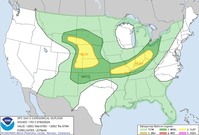
...a two day moderate risk has come out. It's been a year since we've seen this and several years since we've seen it this early in the year.

If you're in Southwest Tennessee, North Mississippi, and Northwest Alabama, be weather alert tomorrow during the daytime and through about 8 PM tomorrow. This is the kind of storm setup that will produce multiple rounds of severe weather in the same areas. If I were predicting, I would say it will get stormy early in the day around the Memphis area and then we'll see a lull through the early afternoon (maybe even dreaded peaks of sunshine) before the fireworks really start hitting late afternoon throughout north and north central Mississippi.

If you're in Alabama, you're in for a really ugly nocturnal event tomorrow night.

Weather nerds, tell me what you're seeing.
 
Last edited:

Hugh's Burner Phone

All-American
Aug 3, 2017
5,407
6,336
113
SE AR, NW MS, and SW TN could see some morning convection. These storms could primarily be elevated in nature and predominantly hailers. Starting around noon the main event starts firing and discrete storms could develop anywhere in the warm sector. Any of these storms have the potential to become tornadic. As they late evening wears on a broken squall line will form ahead of the front and start clearing things out. However, once these storms push into AL during the overnight hours the low level jet should increase and that could spell a nasty nocturnal tornado event in Alabama.
 

FQDawg

Senior
May 1, 2006
3,076
618
113
Can you more specifically define "north and north central Mississippi?"
 

FQDawg

Senior
May 1, 2006
3,076
618
113
Thanks, though that's a lot farther south than anything I'd consider North Mississippi.
 

Drebin

Heisman
Aug 22, 2012
22,505
27,462
113
North of highway 84 I'd have my head on a swivel.

It kinda looks to me like the early discreet stuff is going to be mostly along and just south of the warm front, which will be into Tennessee and extreme North Mississippi, although pretty much the entire state is going to be in an unstable air mass all afternoon so you can't rule out anything, pretty much anywhere. The models are showing a lull until the front comes through late afternoon though.
 

Hugh's Burner Phone

All-American
Aug 3, 2017
5,407
6,336
113
It kinda looks to me like the early discreet stuff is going to be mostly along and just south of the warm front, which will be into Tennessee and extreme North Mississippi, although pretty much the entire state is going to be in an unstable air mass all afternoon so you can't rule out anything, pretty much anywhere. The models are showing a lull until the front comes through late afternoon though.

I'm still debating on where and when to stage, but I'm thinking of the Greenwood area around mid morning. The very early storms may be more elevated in nature and pose mainly a hail threat. I hate crossing the river because if you stray too far from the bridge you just cost yourself the chase trying to get back across into MS, but a Greenwood set up gives me good roads in all four directions so I can be most anyplace in the target area in 90 minutes or so.
 

thatsbaseball

All-American
May 29, 2007
18,376
7,424
113
This is where forecaster's jobs get difficult. You want people in a realistic area to be warned and prepared but you don't want to over do it because if you're way off some people will quit paying attention to your warnings. Pretty heavy stuff in this part of the country where lives are literally on the line in the current type scenario. I live in Madison and personally anticipate being under a tornado watch probably more than one tornado warnings over a 6-8 hour period tomorrow afternoon/early evening. I just pray for everyone's personal and families' safety.
 

Drebin

Heisman
Aug 22, 2012
22,505
27,462
113
I'm still debating on where and when to stage, but I'm thinking of the Greenwood area around mid morning. The very early storms may be more elevated in nature and pose mainly a hail threat. I hate crossing the river because if you stray too far from the bridge you just cost yourself the chase trying to get back across into MS, but a Greenwood set up gives me good roads in all four directions so I can be most anyplace in the target area in 90 minutes or so.

Best of luck and stay safe. These setups are scary because these supercells can train each other. There's a high likelihood that tornadoes will be rain-wrapped, too.
 
Nov 12, 2007
26,013
10,168
113
This is where forecaster's jobs get difficult. You want people in a realistic area to be warned and prepared but you don't want to over do it because if you're way off some people will quit paying attention to your warnings. Pretty heavy stuff in this part of the country where lives are literally on the line in the current type scenario. I live in Madison and personally anticipate being under a tornado watch probably more than one tornado warnings over a 6-8 hour period tomorrow afternoon/early evening. I just pray for everyone's personal and families' safety.


Don't think if it is quiet at 3 PM in your neck of the woods that it's a bust. It is possible to get something in one of three rounds tomorrow. The warm front, the warm sector, and then the last line which looks to be more of a string of supercells tied together rather than a connected line.

View attachment 19746
 

thatsbaseball

All-American
May 29, 2007
18,376
7,424
113
Oh I'll be watching for "all the above" I'm just saying I anticipate it to be pretty intense here for several long hours regardless of how the storms originate. I can honestly say that I've never considered being warned of potential bad weather that didn't happen a "bust"....I know it's a tough job and would rather err on the safe side anytime.
 

Hugh's Burner Phone

All-American
Aug 3, 2017
5,407
6,336
113
SPC update is not good. They are contemplating a high risk upgrade. Below is their wording. This is flat out scary.

FURTHER EAST ACROSS NORTHEAST LA INTO MS AND AL A MORE CONCERNING
SCENARIO APPEARS POSSIBLE. MOST FORECAST GUIDANCE AGREES THAT A
ROUND OF AFTERNOON THUNDERSTORMS ARE EXPECTED. THIS ACTIVITY IS
EXPECTED TO DEVELOP IN WEAKER ASCENT, DRIVEN BY HEATING AND LOW
LEVEL WARM ADVECTION. STRONG 0-3 KM SHEAR NEAR 30-40 KT WILL ALREADY
BE IN PLACE WITH ENLARGED LOW LEVEL HODOGRAPHS EVIDENT. GIVEN WEAKER
FORCING, THIS ACTIVITY WILL HAVE AN OPPORTUNITY TO REMAIN MORE
DISCRETE AND ANY CELL WILL QUICKLY BECOME A SUPERCELL CAPABLE OF
PRODUCING STRONG TORNADOES. AS A 40-50 KT LOW LEVEL JET INCREASES
AROUND 00-03Z, INTENSE SUPERCELLS ARE EXPECTED TO ADVANCE EASTWARD
ALONG WITH THE COLD FRONT ACROSS MS AND INTO AL OVERNIGHT. THIS WILL
BRING A SECOND ROUND OF SIGNIFICANT SEVERE STORMS CAPABLE OF INTENSE
TORNADOES, LARGE HAIL AND INTENSE DAMAGING WINDS ACROSS MUCH OF
MS/AL. IF THESE TRENDS ARE MAINTAINED, AN UPGRADE TO A HIGH RISK
COULD BE NECESSARY WITH THE INITIAL DAY 1 CONVECTIVE OUTLOOK AT 06Z
TONIGHT.
 

AlCoDog

All-Conference
Feb 27, 2008
5,870
1,435
113
My wife and 2 of my kids are supposed to be driving from Santa Rosa to Madison, MS tomorrow morning. I’m extremely concerned. Debating on whether or not to tell them to stay another night.
 

Hugh's Burner Phone

All-American
Aug 3, 2017
5,407
6,336
113
My wife and 2 of my kids are supposed to be driving from Santa Rosa to Madison, MS tomorrow morning. I’m extremely concerned. Debating on whether or not to tell them to stay another night.

That in FL? Tell them to stay if possible. I'm not one to overhype things but tomorrow has a very real potential to be really bad. I'll just leave it at that. It may end up busting and there being nothing to it, but I really don't think so.
 

RocketDawg

All-Conference
Oct 21, 2011
20,003
2,780
113
Looked like there was some potential there, but couldn't really tell if it was rotating.

According to the Weather Channel, there's a potential rotating storm moving into Georgia from Alabama, close to I-20 right now.
 

Drebin

Heisman
Aug 22, 2012
22,505
27,462
113
they also expanded the moderate area.


This is a ridiculously large area in the moderate (4/5) zone. I expect a portion if it to go high (5/5) in tonight's run.
 

RivaDawg

Senior
Feb 26, 2008
887
433
63
That in FL? Tell them to stay if possible. I'm not one to overhype things but tomorrow has a very real potential to be really bad. I'll just leave it at that. It may end up busting and there being nothing to it, but I really don't think so.

Are you a storm chaser?

Why and do you have any cool/interesting/scary things that you have seen chasing storms?
 

Hugh's Burner Phone

All-American
Aug 3, 2017
5,407
6,336
113
Are you a storm chaser?

Why and do you have any cool/interesting/scary things that you have seen chasing storms?

I am a Storm Chaser. I guess my scariest moment would be a tie between dead centering the Tishomingo tornado last April and a chase a few years ago over in AR. I had lost all cell service so I had no radar for the last 20 minutes. I had a tornado warned storm behind me that was also dropping baseballs at last report. I didn't care as I was done for the day and heading home. That changed when my road was closed due to flooding. So with no radar I had no choice but to turn around and drive right back through that storm that I had no idea what it was doing.

The most interesting was a tornado a couple years ago down near Mt Olive. It destroyed a shed. Actually ripped it from the foundation and moved it about three feet. However, inside were two four wheelers. On both of them it ripped the seat off but otherwise never put a scratch on them.

The most sobering storm I chased was the Louisville tornado. I live in Starkville and had debris in my yard from that tornado. I found a receipt that had a woman's name on it. I googled it just to see if it I could find her in case it was something she needed back. It turns out she was the lady that ran the daycare that died laying on top of the kids there to protect them.

But just seeing the damage these things can do is awe inspiring and gut wrenching at the same time.
 

RivaDawg

Senior
Feb 26, 2008
887
433
63
I am a Storm Chaser. I guess my scariest moment would be a tie between dead centering the Tishomingo tornado last April and a chase a few years ago over in AR. I had lost all cell service so I had no radar for the last 20 minutes. I had a tornado warned storm behind me that was also dropping baseballs at last report. I didn't care as I was done for the day and heading home. That changed when my road was closed due to flooding. So with no radar I had no choice but to turn around and drive right back through that storm that I had no idea what it was doing.

The most interesting was a tornado a couple years ago down near Mt Olive. It destroyed a shed. Actually ripped it from the foundation and moved it about three feet. However, inside were two four wheelers. On both of them it ripped the seat off but otherwise never put a scratch on them.

The most sobering storm I chased was the Louisville tornado. I live in Starkville and had debris in my yard from that tornado. I found a receipt that had a woman's name on it. I googled it just to see if it I could find her in case it was something she needed back. It turns out she was the lady that ran the daycare that died laying on top of the kids there to protect them.

But just seeing the damage these things can do is awe inspiring and gut wrenching at the same time.

Thanks for the response. Do you work for someone or independent contractor/researcher? I could never do what you do, but when tornado sirens go off I stand on the front porch to see what is going on.
 

Hugh's Burner Phone

All-American
Aug 3, 2017
5,407
6,336
113
Thanks for the response. Do you work for someone or independent contractor/researcher? I could never do what you do, but when tornado sirens go off I stand on the front porch to see what is going on.

I'm with north ms storm chasers. We're tied in with WTVA but we're all voluntary. We don't make any money unless we sale video.
 

Treemydawg

Sophomore
Sep 29, 2013
314
128
43
I am a Storm Chaser. I guess my scariest moment would be a tie between dead centering the Tishomingo tornado last April and a chase a few years ago over in AR. I had lost all cell service so I had no radar for the last 20 minutes. I had a tornado warned storm behind me that was also dropping baseballs at last report. I didn't care as I was done for the day and heading home. That changed when my road was closed due to flooding. So with no radar I had no choice but to turn around and drive right back through that storm that I had no idea what it was doing.

The most interesting was a tornado a couple years ago down near Mt Olive. It destroyed a shed. Actually ripped it from the foundation and moved it about three feet. However, inside were two four wheelers. On both of them it ripped the seat off but otherwise never put a scratch on them.

The most sobering storm I chased was the Louisville tornado. I live in Starkville and had debris in my yard from that tornado. I found a receipt that had a woman's name on it. I googled it just to see if it I could find her in case it was something she needed back. It turns out she was the lady that ran the daycare that died laying on top of the kids there to protect them.

But just seeing the damage these things can do is awe inspiring and gut wrenching at the same time.

I for one will never forget riding along with you on that AR chase. It is in my top two scariest moments of my life right next to the Meridian tornado three years ago centering the car my wife and I were riding in.
 

maroonmadman

Senior
Nov 7, 2010
2,530
853
113
I am a Storm Chaser. I guess my scariest moment would be a tie between dead centering the Tishomingo tornado last April and a chase a few years ago over in AR. I had lost all cell service so I had no radar for the last 20 minutes. I had a tornado warned storm behind me that was also dropping baseballs at last report. I didn't care as I was done for the day and heading home. That changed when my road was closed due to flooding. So with no radar I had no choice but to turn around and drive right back through that storm that I had no idea what it was doing.

The most interesting was a tornado a couple years ago down near Mt Olive. It destroyed a shed. Actually ripped it from the foundation and moved it about three feet. However, inside were two four wheelers. On both of them it ripped the seat off but otherwise never put a scratch on them.

The most sobering storm I chased was the Louisville tornado. I live in Starkville and had debris in my yard from that tornado. I found a receipt that had a woman's name on it. I googled it just to see if it I could find her in case it was something she needed back. It turns out she was the lady that ran the daycare that died laying on top of the kids there to protect them.

But just seeing the damage these things can do is awe inspiring and gut wrenching at the same time.

Some years back, in the 90's I believe, a tornado touched down in Rankin Co., near Star, and traveled all the way up to where I lived in Attala Co. The next day I went to a friends parents house to help put a tarp on their damaged roof. After we finished we drove out through their pasture (debris were everywhere) looking to see if we could find anything valuable. We didn't, but we did find a box on slightly soggy envelopes that were marked from the Baptist Church in Star. That was a trip of about 70 miles.
 
Maroon and White

Latest

  1. 01 Maroon and White Football Mississippi State Keys to Victory against Alabama
  2. 02 Maroon and White No. 16 Mississippi State vs. No. 7 Alabama: How, where and when to watch the Bulldogs
  3. 03 Maroon and White Mississippi State Soccer preps for No. 11 South Carolina
  4. 04 Maroon and White Football Mississippi State's Zakari Tillman Out vs. Alabama
  5. 05 Maroon and White Football Will Mississippi State's secondary be the difference on Saturday?