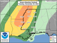
Significant severe weather, including strong tornadoes, is now looking increasingly likely for overnight Tuesday into early Wednesday morning for much of MS with the northwestern part of the state being the most favored. An enhanced severe risk has been outlined by the SPC for this area and an upgrade to moderate closer to Tuesday will probably happen if forecasts hold on the dynamics of the system. The first graphic below is the current SPC risk area and the second is the significant tornado parameter for midnight Wednesday from the NAM. Expect some fluctuations in this, but overall this is looking pretty solid. I want to stress this is setting up to be a potentially significant event which will only be made worse by it happening late at night. Have multiple ways to get warnings. As the storms move into the rest of MS they are expecting to weaken and become more linear.
Can't get the STP image to load. I guess the new site won't load images above a certain file size.
Can't get the STP image to load. I guess the new site won't load images above a certain file size.