OT: Weekend snowstorm - historic blizzzard
- Thread starter Mikemarc
- Start date
You are using an out of date browser. It may not display this or other websites correctly.
You should upgrade or use an alternative browser.
You should upgrade or use an alternative browser.

The snow just melted from the last storm minus small batches of dirty snow. This winter has been in a kick in the ballsI'm crying I don't want to deal with this ****
NY/PA WEATHER STEVE DI MARTINO
GOING FOR SOME LOWER AMOUNTS IN PARTS OF NJ DUE TO SUBSIDENCE
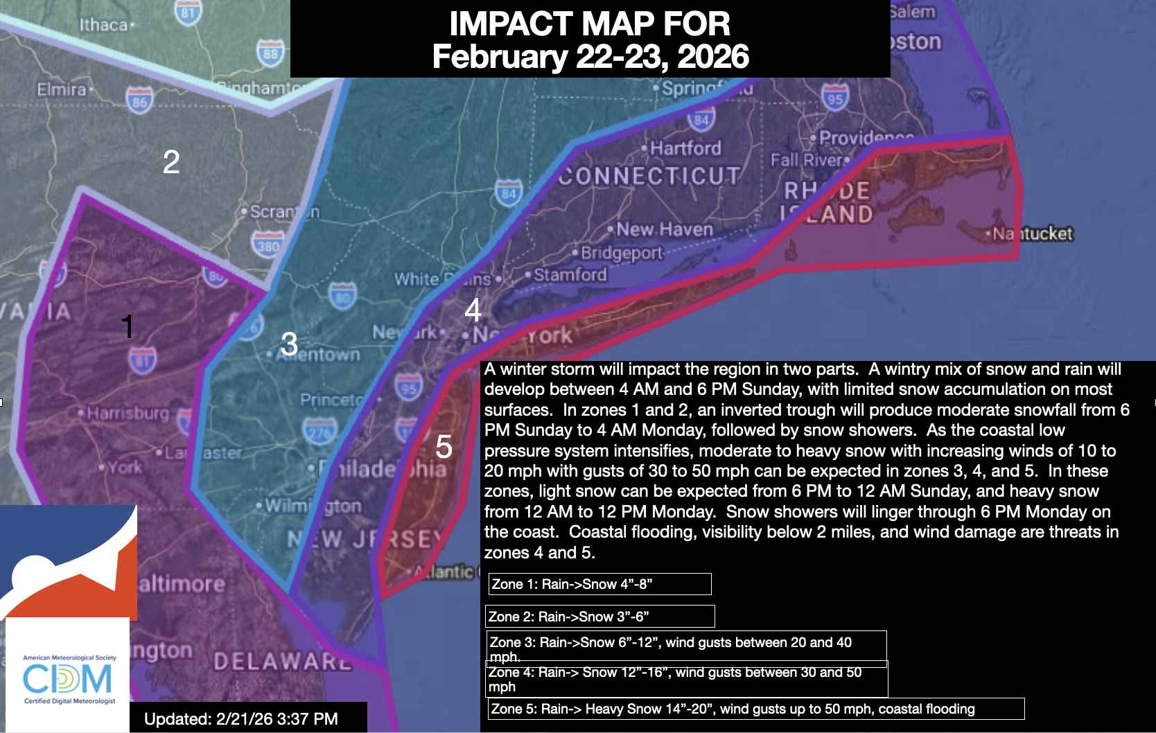
UPDATED 02/21/26 5:01 PM
A major winter storm will impact the region tomorrow through Monday morning with a variety of impacts. Here are the details on this storm.
SUNDAY: 4 AM to 6 PM
As the low-pressure system develops to our south, scattered rain and snow showers will develop around the region. With temperatures in the 30s and 40s, snow accumulation will not be expected in this time period. Most of the region can expect temperatures to begin to fall towards freezing in the evening with minor snow accumulation on cold surfaces.
SUNDAY 6 PM to 12 AM
As the new coastal low-pressure system intensifies, an inverted trough will develop from the Delaware Coast to southeastern Pennsylvania, producing moderate snowfall in zone 1 and light snowfall in zone 2. With temperatures falling below freezing, snow accumulation will begin to increase on all surfaces. Meanwhile, light snowfall will begin to accumulate in zones 3, 4, and 5.
MONDAY 12 AM to 12 PM
The coastal low-pressure system takes over and rapidly intensifies. As temperatures fall between the upper 20s and lower 30s throughout the region, all locations can expect snow accumulation. The snowfall will pick up intensity in zones 4 and 5, while zone 1 sees a decrease in intensity. Zone 3 will be caught between the two heavy snowfall zones, which will keep the snowfall light to moderate. Meanwhile, the intensifying low-pressure system will support winds of 15 to 30 mph on the coast with gusts between 30 and 50 mph. Poor visibility and power outages will be a threat in zones 4 and 5. Coastal flooding will be a threat in zone 5.
MONDAY 12 PM to 6 PM
The low-pressure system departs with lingering snow showers. Temperatures will be in the lower to mid-30s with limited, if any, additional snowfall accumulation.
This snowfall will be a heavy, wet type of snow. Use caution with snow removal!
Additional Impacts:
There is a high threat of coastal flooding along the New Jersey coast and Long Island with the tides one to two feet above ground level from tomorrow evening through Monday morning.
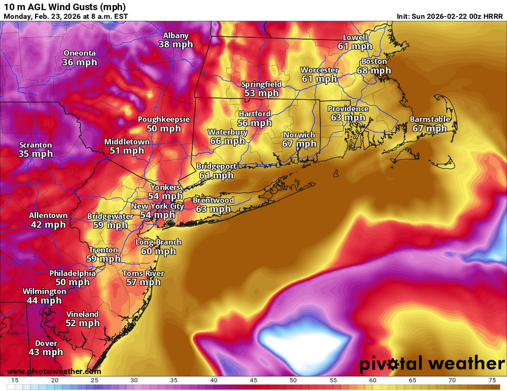
The combination of sustained winds of 15 to 30 mph and gusts up to 60 mph will produce visibility below a mile, power outages, and minor to moderate wind damage.
The primary bust potential for this storm is where the intense snow band sets up.
Many have asked why, in zone 3, I am going so low when many outlets, including the NWS, are going significantly higher. The answer comes down to rising and sinking motion.
If there are going to be snowfall rates of 1″ to 4″ per hour on the coast, then there must be an equal and opposite reaction. That reaction is experienced in many winter storms, and this one will be no different.
With an inverted trough over southeastern Pennsylvania tomorrow evening, enhancing snowfall totals in east-central Pennsylvania and lifting intensifying along the coast, there must be an area of sinking air around the Delaware River Valley and northern New Jersey. However, some guidance pushes this banding further west, towards the Hudson Highlands and the Delaware Water Gap, which would expand the potential for intense snowfall rates. Still, the process remains, and that means sinking air will also shift to the west. My point is that some locations are going to have periods of very light snow, while locations to the east will experience blizzard conditions. The question is not if, but simply where. Thus the bust potential in some of these locations away from the coast.
This is going to be a very complicated storm, and there is no doubt that this storm will produce intense snowfall. Regardless of whether you have 6″, 12″, or 24″, this snow will be of the heavy, wet variety and very difficult to move. Please use caution when shovelling.
Also, this storm will make travel conditions very poor tomorrow night through Monday morning. If possible, please do not travel and work from home. Visibility will be near zero, and wind gusts will create dangerous conditions. Let the people who bravely go out to clear up the streets for this storm do their job. Perhaps hand out some coffee for them while you are at it.
GOING FOR SOME LOWER AMOUNTS IN PARTS OF NJ DUE TO SUBSIDENCE
UPDATED 02/21/26 5:01 PM
A major winter storm will impact the region tomorrow through Monday morning with a variety of impacts. Here are the details on this storm.
SUNDAY: 4 AM to 6 PM
As the low-pressure system develops to our south, scattered rain and snow showers will develop around the region. With temperatures in the 30s and 40s, snow accumulation will not be expected in this time period. Most of the region can expect temperatures to begin to fall towards freezing in the evening with minor snow accumulation on cold surfaces.
SUNDAY 6 PM to 12 AM
As the new coastal low-pressure system intensifies, an inverted trough will develop from the Delaware Coast to southeastern Pennsylvania, producing moderate snowfall in zone 1 and light snowfall in zone 2. With temperatures falling below freezing, snow accumulation will begin to increase on all surfaces. Meanwhile, light snowfall will begin to accumulate in zones 3, 4, and 5.
MONDAY 12 AM to 12 PM
The coastal low-pressure system takes over and rapidly intensifies. As temperatures fall between the upper 20s and lower 30s throughout the region, all locations can expect snow accumulation. The snowfall will pick up intensity in zones 4 and 5, while zone 1 sees a decrease in intensity. Zone 3 will be caught between the two heavy snowfall zones, which will keep the snowfall light to moderate. Meanwhile, the intensifying low-pressure system will support winds of 15 to 30 mph on the coast with gusts between 30 and 50 mph. Poor visibility and power outages will be a threat in zones 4 and 5. Coastal flooding will be a threat in zone 5.
MONDAY 12 PM to 6 PM
The low-pressure system departs with lingering snow showers. Temperatures will be in the lower to mid-30s with limited, if any, additional snowfall accumulation.
This snowfall will be a heavy, wet type of snow. Use caution with snow removal!
Additional Impacts:
There is a high threat of coastal flooding along the New Jersey coast and Long Island with the tides one to two feet above ground level from tomorrow evening through Monday morning.
The combination of sustained winds of 15 to 30 mph and gusts up to 60 mph will produce visibility below a mile, power outages, and minor to moderate wind damage.
The primary bust potential for this storm is where the intense snow band sets up.
Many have asked why, in zone 3, I am going so low when many outlets, including the NWS, are going significantly higher. The answer comes down to rising and sinking motion.
If there are going to be snowfall rates of 1″ to 4″ per hour on the coast, then there must be an equal and opposite reaction. That reaction is experienced in many winter storms, and this one will be no different.
With an inverted trough over southeastern Pennsylvania tomorrow evening, enhancing snowfall totals in east-central Pennsylvania and lifting intensifying along the coast, there must be an area of sinking air around the Delaware River Valley and northern New Jersey. However, some guidance pushes this banding further west, towards the Hudson Highlands and the Delaware Water Gap, which would expand the potential for intense snowfall rates. Still, the process remains, and that means sinking air will also shift to the west. My point is that some locations are going to have periods of very light snow, while locations to the east will experience blizzard conditions. The question is not if, but simply where. Thus the bust potential in some of these locations away from the coast.
This is going to be a very complicated storm, and there is no doubt that this storm will produce intense snowfall. Regardless of whether you have 6″, 12″, or 24″, this snow will be of the heavy, wet variety and very difficult to move. Please use caution when shovelling.
Also, this storm will make travel conditions very poor tomorrow night through Monday morning. If possible, please do not travel and work from home. Visibility will be near zero, and wind gusts will create dangerous conditions. Let the people who bravely go out to clear up the streets for this storm do their job. Perhaps hand out some coffee for them while you are at it.
For the love of god, please spare the western parts of NJ.
sometime in the afternoon...will likely be wet snow at firstSorry didn't want to go through the whole thread but what time will this begin to stick in Hunterdon county?

EPA Weather


Weather Alerts
There are no current/valid alert products Last updated: 3:00 PM Wednesday March 4th, 2026 Overview: Storm impact level and timing: Snow impacts: Snow consistency: Ice impacts: Rain impacts: Wind impacts: Travel disruptions: Power outage concerns: School cancellations/delays: For more...
epawaweather.com
Weather Channel app on the daily for my are says 1-3” tomorrow and 1-3” Monday lol. It’s so wrong. The app stinks

ETA for the storm in Upper Somerset County? I might try getting to gym in a.m., but of course not too early lol.sometime in the afternoon...will likely be wet snow at first

The NAM just went crazy. I never saw them colors before on these maps. WOW

Precip should be wet type snow at first if arrives before noonETA for the storm in Upper Somerset County? I might try getting to gym in a.m., but of course not too early lol.
The NAM just went crazy. I never saw them colors before on these maps. WOW

Thanks, gym will be a game-time decision for me then. I have just enough weights at home to get a decent workout if I'm not motivated in the a.m.Precip should be wet type snow at first if arrives before noon
Not leaving the house tomorrow except to clear snow or go for a walk. I hope to build a sled run in the backyard using patio stairs and our natural slope
The NAM just went crazy. I never saw them colors before on these maps. WOW
42 inches for Toms River, stop. I’m gonna give my prediction for my house in Piscataway as an under, I’ll go with 12.5 inches, which is still a **** ton of heavy snowThe NAM just went crazy. I never saw them colors before on these maps. WOW
Sadly, I'll take the over for 20 inches in Metuchen.42 inches for Toms River, stop. I’m gonna give my prediction for my house in Piscataway as an under, I’ll go with 12.5 inches, which is still a **** ton of heavy snow
0z gfs perhaps ticked down a tad 12 nw to 20 cj...as you get to coast it was 20-30
0z ai gfs 10-16 throughout nj
0z ai gfs 10-16 throughout nj
I was just getting used to n and s of 95 now my mind is blown0z Reggie is the least snowiest model 7-12 nw of 95 and 12-16 SE of 95
You can blame me and @RUPete90 . Sorry about that.I was just getting used to n and s of 95 now my mind is blown
Does nobody read my posts, lol? 95 runs SW to NE and the snowfall, precip and mixing gradients are often (but not always) perpendicular to 95 with a nor'easter, which typically moves SW to NE, parallel to 95. So, when a storm moves that direction the precip gradient goes from SE to NW, perpendicular to the track. That's why the coast is getting more precip and snow (when the precip for all is snow like now) than 95 or NW of 95 as it's closer to the storm's center. But when there's enough warm air to turn the snow to rain, that happens first at the coast and the rain/snow line often moves inland from SE to NW, meaning areas towards the coast can get more precip, but less snow than areas along 95 or inland of there. That's why you'll usually see me talking about NW and SE of 95, as you can fairly easily see that in the snowfall gradients on the maps.I was just getting used to n and s of 95 now my mind is blown
Occasionally, storm tracks are more W to E (like 1/25), so then the gradients will usually set up perpendicular to the track, i.e., precip/snow declining as one moves further N of the storm - for those storms I often use highways like 276/195, 78 and 84 as they are E-W roads and mention the gradient being north or south of tose lines.
Just got home, checked the models and didn't see anything that would likely cause any forecast change, as the models mostly held their ground. I'm pretty sore from dancing all night with my wife and friends at the Melody Reunion - might've been the best music sets I can recall, collectively. Fun night and there's no way I'm doing any long weather posts now, lol. Time to watch the radar and the sky soon. Potential is there for a huge blizzard, but still enough questions about which model camp will win out - the lower accumulation models have some chance of being right. That's why took the under on my house prediction of 18.5" vs. the NWS prediction of 20" for my house. Time for some sleep, as I'm sure I won't sleep tomorrow night - too excited to watch this unfold and document it plus I even like shoveling snow. Stay safe, but enjoy the beauty of it all.
bac threw a hissyfit for my daring to challenge being North and South of I-95.Does nobody read my posts, lol? 95 runs SW to NE and the snowfall, precip and mixing gradients are often (but not always) perpendicular to 95 with a nor'easter, which typically moves SW to NE, parallel to 95. So, when a storm moves that direction the precip gradient goes from SE to NW, perpendicular to the track. That's why the coast is getting more precip and snow (when the precip for all is snow like now) than 95 or NW of 95 as it's closer to the storm's center. But when there's enough warm air to turn the snow to rain, that happens first at the coast and the rain/snow line often moves inland from SE to NW, meaning areas towards the coast can get more precip, but less snow than areas along 95 or inland of there. That's why you'll usually see me talking about NW and SE of 95, as you can fairly easily see that in the snowfall gradients on the maps.
Occasionally, storm tracks are more W to E (like 1/25), so then the gradients will usually set up perpendicular to the track, i.e., precip/snow declining as one moves further N of the storm - for those storms I often use highways like 276/195, 78 and 84 as they are E-W roads and mention the gradient being north or south of tose lines.
This Guy Meteo Mark is good !
At least for this storm!
He was calling for 18-24 inch blizzard a week ago !
Hasn’t waivered !
I was just busting. Maybe you’re just tired and cranky after the Melody Reunion?Does nobody read my posts, lol? 95 runs SW to NE and the snowfall, precip and mixing gradients are often (but not always) perpendicular to 95 with a nor'easter, which typically moves SW to NE, parallel to 95. So, when a storm moves that direction the precip gradient goes from SE to NW, perpendicular to the track. That's why the coast is getting more precip and snow (when the precip for all is snow like now) than 95 or NW of 95 as it's closer to the storm's center. But when there's enough warm air to turn the snow to rain, that happens first at the coast and the rain/snow line often moves inland from SE to NW, meaning areas towards the coast can get more precip, but less snow than areas along 95 or inland of there. That's why you'll usually see me talking about NW and SE of 95, as you can fairly easily see that in the snowfall gradients on the maps.
Occasionally, storm tracks are more W to E (like 1/25), so then the gradients will usually set up perpendicular to the track, i.e., precip/snow declining as one moves further N of the storm - for those storms I often use highways like 276/195, 78 and 84 as they are E-W roads and mention the gradient being north or south of tose lines.
What time can you come shovel my driveway?Just got home, checked the models and didn't see anything that would likely cause any forecast change, as the models mostly held their ground. I'm pretty sore from dancing all night with my wife and friends at the Melody Reunion - might've been the best music sets I can recall, collectively. Fun night and there's no way I'm doing any long weather posts now, lol. Time to watch the radar and the sky soon. Potential is there for a huge blizzard, but still enough questions about which model camp will win out - the lower accumulation models have some chance of being right. That's why took the under on my house prediction of 18.5" vs. the NWS prediction of 20" for my house. Time for some sleep, as I'm sure I won't sleep tomorrow night - too excited to watch this unfold and document it plus I even like shoveling snow. Stay safe, but enjoy the beauty of it all.