better bet than most places....id say 10-14 but closer to 10 if sleet gets your wayIs it gonna be all snow for me in western Bergen?
OT: Spring Warmth, 3/5-3/12+? Winter 2025-26 - Patterns and Potential Winter Storms
- Thread starter RU848789
- Start date
You are using an out of date browser. It may not display this or other websites correctly.
You should upgrade or use an alternative browser.
You should upgrade or use an alternative browser.

98% yes with maybe a little sleet at the end; significant sleet is not shown anywhere near you on any model I know of...but we're still 2 days out, so can't discount it completely.Is it gonna be all snow for me in western Bergen?
He really hasn't changed his map since yesterday and I liked it then and still, although I like DTs map better as it shows the freezing rain threat and the floor being 8" for folks NW of Wilmington to Pt. Pleasant especially considering good ratios early on. Also, for folks looking at this, his "mixing favors lower totals" area, largely SE of 95, he means on the low side of 6-12", not less than 6"Lee Goldberg
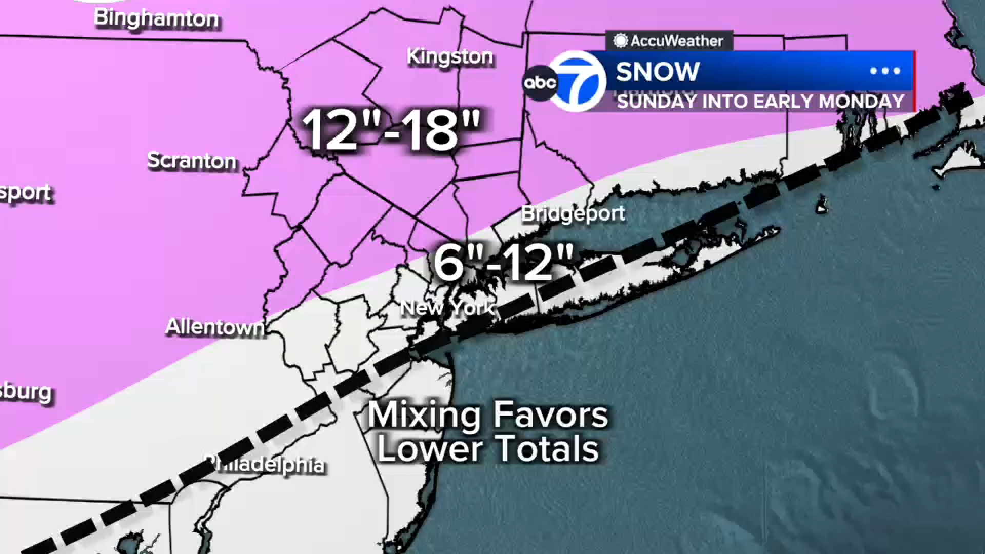
Given that the 12Z models that just came out have generally trended a little bit colder/less sleety, Lee Goldberg/AccuWeather bumped up their snowfall amounts a bit from 6-12" for most to 8-12" with the 8" line from about Dover DE to Sea Bright and 4-8" SE of that line. I still think nobody in NJ gets less than 6" even if they get a lot of sleet later on especially in his 4-8" area towards the coast (I'd have that area as 6-8"). His map now looks very similar to DT/WxRisk's map.

They are still way too bullish IMO but they did cut back a little.
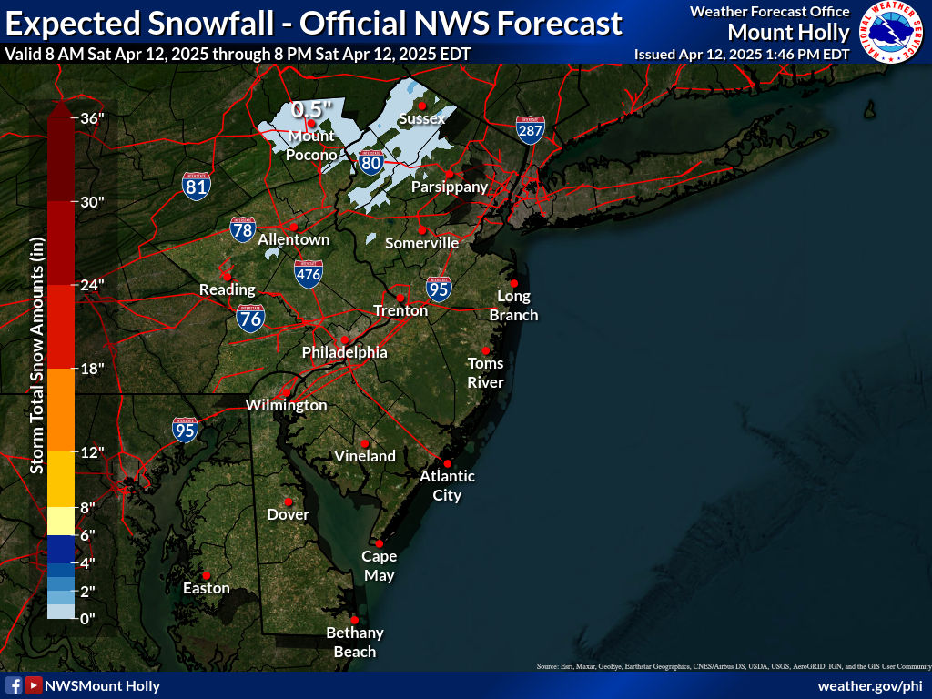
And we have warnings up for everyone for snow/precip from about 4 am to 10-11 pm Sunday (with light precip into Monday morning) covered by the NWS-Philly and NYC offices...they are condensed, below. A summary is bulleted below; the first 4 bullets are the counties under the NWS-Philly, while the last 2 are under NWS-NYC. One can argue that these numbers are a bit aggressive vs. other forecasters, but the NWS hasn't wavered, really, other than knocking down snowfall forecasts a bit south of 78 due to some sleet and adding in some ZR. There are plenty of models that show these amounts given good ratios (like 12-15:1), so it's not like the forecast is crazy, just higher than most; their latest map is below. With temps below 20F for most and some wind, it'll be frigid and salt won't work as well, plus there will be some wind (20-25 mph) so some drifting is possible.
URGENT - WINTER WEATHER MESSAGE
National Weather Service Mount Holly NJ
1238 PM EST Fri Jan 23 2026
New Castle-Kent-Kent MD-Queen Annes-Talbot-Caroline-Salem-
Gloucester-Camden-Northwestern Burlington-Cumberland-Southeastern
Burlington-Delaware-Philadelphia-Western Chester-Eastern Chester-
Eastern Montgomery-
1238 PM EST Fri Jan 23 2026
...WINTER STORM WARNING IN EFFECT FROM 7 PM SATURDAY TO 1 PM EST
MONDAY...
* WHAT...Heavy snow and mixed precipitation expected. Total snow
accumulations between 8 and 12 inches and ice accumulations around
three tenths of an inch.
URGENT - WINTER WEATHER MESSAGE
National Weather Service Mount Holly NJ
1238 PM EST Fri Jan 23 2026
Inland Sussex-Delaware Beaches-Atlantic-Cape May-Atlantic Coastal
Cape May-Coastal Atlantic-
Including the cities of Rehoboth Beach, Ocean City, Atlantic
City, Cape May Court House, Hammonton, and Georgetown
1238 PM EST Fri Jan 23 2026
...WINTER STORM WARNING IN EFFECT FROM 7 PM SATURDAY TO 7 AM EST
MONDAY...
* WHAT...Heavy snow with mixed precipitation expected. Total snow
accumulations between 6 and 10 inches and ice accumulations around
one tenth of an inch. Winds gusting as high as 35 mph.
URGENT - WINTER WEATHER MESSAGE
National Weather Service Mount Holly NJ
1238 PM EST Fri Jan 23 2026
Sussex-Warren-Carbon-Monroe-Lehigh-Northampton-
Including the cities of Allentown, Stroudsburg, Bethlehem,
Easton, Jim Thorpe, Newton, and Washington
1238 PM EST Fri Jan 23 2026
...WINTER STORM WARNING IN EFFECT FROM 1 AM SUNDAY TO 1 PM EST
MONDAY...
* WHAT...Heavy snow expected. Total snow accumulations between 12
and 18 inches and ice accumulations around a light glaze.
URGENT - WINTER WEATHER MESSAGE
National Weather Service Mount Holly NJ
1238 PM EST Fri Jan 23 2026
Morris-Hunterdon-Somerset-Middlesex-Western Monmouth-Eastern
Monmouth-Mercer-Ocean-Coastal Ocean-Berks-Western Montgomery-
Upper Bucks-Lower Bucks-
1238 PM EST Fri Jan 23 2026
...WINTER STORM WARNING IN EFFECT FROM 7 PM SATURDAY TO 1 PM EST
MONDAY...
* WHAT...Heavy snow with mixed precipitation expected. Total snow
accumulations between 10 and 15 inches and ice accumulations
around one tenth of an inch.
URGENT - WINTER WEATHER MESSAGE
National Weather Service New York NY
112 PM EST Fri Jan 23 2026
Northern Fairfield-Northern New Haven-Northern Middlesex-Northern
New London-Southern Fairfield-Southern New Haven-Southern
Middlesex-Southern New London-Western Passaic-Orange-Putnam-
Rockland-Northern Westchester-
112 PM EST Fri Jan 23 2026
...WINTER STORM WARNING IN EFFECT FROM 3 AM SUNDAY TO 6 PM EST
MONDAY...
* WHAT...Heavy snow expected. Total snow accumulations between 12
and 16 inches.
URGENT - WINTER WEATHER MESSAGE
National Weather Service New York NY
112 PM EST Fri Jan 23 2026
Eastern Passaic-Hudson-Western Bergen-Eastern Bergen-Western
Essex-Eastern Essex-Western Union-Eastern Union-Southern
Westchester-New York (Manhattan)-Bronx-Richmond (Staten Island)-
Kings (Brooklyn)-Northwest Suffolk-Northeast Suffolk-Southwest
Suffolk-Southeast Suffolk-Northern Queens-Northern Nassau-
Southern Queens-Southern Nassau-
112 PM EST Fri Jan 23 2026
...WINTER STORM WARNING IN EFFECT FROM 3 AM SUNDAY TO 6 PM EST
MONDAY...
* WHAT...Heavy snow expected. Total snow accumulations between 10
and 14 inches. A changeover to a wintry mix is possible Sunday
evening and could lead to additional sleet accumulation and a
glaze of ice before a change back over to light snow later Sunday
night. Isolated wind gusts of 35 to 40 mph are possible for
eastern long Island.

- For counties S of 276/195 in SEPA/SNJ/N DE, the warning is for 8-12" of snow/sleet plus about 0.3" of freezing rain (ZR)
- For Atlantic/Cape May counties and southern DE, the warning is for 6-10" of snow/sleet plus about 0.1" ZR
- For Sussex/Warren/Poconos/Lehigh Valley, the warning is for 12-18" of snow plus a light glaze of ZR
- For Morris-Hunterdon-Somerset-Middlesex-Monmouth-Mercer-Ocean-W Montco and Bucks, the warning is for 10-15" of snow/sleet, plus about 0.1" of ZR
- For W. Passaic, the entire Hudson Valley and the coastal CT counties, the warning is for 12-16" of snow
- For NENJ (Union/Essex/Hudson/Bergen/E Passaic), NYC and LI, the warning is for 10-14" snow/sleet plus a light glaze of ZR
URGENT - WINTER WEATHER MESSAGE
National Weather Service Mount Holly NJ
1238 PM EST Fri Jan 23 2026
New Castle-Kent-Kent MD-Queen Annes-Talbot-Caroline-Salem-
Gloucester-Camden-Northwestern Burlington-Cumberland-Southeastern
Burlington-Delaware-Philadelphia-Western Chester-Eastern Chester-
Eastern Montgomery-
1238 PM EST Fri Jan 23 2026
...WINTER STORM WARNING IN EFFECT FROM 7 PM SATURDAY TO 1 PM EST
MONDAY...
* WHAT...Heavy snow and mixed precipitation expected. Total snow
accumulations between 8 and 12 inches and ice accumulations around
three tenths of an inch.
URGENT - WINTER WEATHER MESSAGE
National Weather Service Mount Holly NJ
1238 PM EST Fri Jan 23 2026
Inland Sussex-Delaware Beaches-Atlantic-Cape May-Atlantic Coastal
Cape May-Coastal Atlantic-
Including the cities of Rehoboth Beach, Ocean City, Atlantic
City, Cape May Court House, Hammonton, and Georgetown
1238 PM EST Fri Jan 23 2026
...WINTER STORM WARNING IN EFFECT FROM 7 PM SATURDAY TO 7 AM EST
MONDAY...
* WHAT...Heavy snow with mixed precipitation expected. Total snow
accumulations between 6 and 10 inches and ice accumulations around
one tenth of an inch. Winds gusting as high as 35 mph.
URGENT - WINTER WEATHER MESSAGE
National Weather Service Mount Holly NJ
1238 PM EST Fri Jan 23 2026
Sussex-Warren-Carbon-Monroe-Lehigh-Northampton-
Including the cities of Allentown, Stroudsburg, Bethlehem,
Easton, Jim Thorpe, Newton, and Washington
1238 PM EST Fri Jan 23 2026
...WINTER STORM WARNING IN EFFECT FROM 1 AM SUNDAY TO 1 PM EST
MONDAY...
* WHAT...Heavy snow expected. Total snow accumulations between 12
and 18 inches and ice accumulations around a light glaze.
URGENT - WINTER WEATHER MESSAGE
National Weather Service Mount Holly NJ
1238 PM EST Fri Jan 23 2026
Morris-Hunterdon-Somerset-Middlesex-Western Monmouth-Eastern
Monmouth-Mercer-Ocean-Coastal Ocean-Berks-Western Montgomery-
Upper Bucks-Lower Bucks-
1238 PM EST Fri Jan 23 2026
...WINTER STORM WARNING IN EFFECT FROM 7 PM SATURDAY TO 1 PM EST
MONDAY...
* WHAT...Heavy snow with mixed precipitation expected. Total snow
accumulations between 10 and 15 inches and ice accumulations
around one tenth of an inch.
URGENT - WINTER WEATHER MESSAGE
National Weather Service New York NY
112 PM EST Fri Jan 23 2026
Northern Fairfield-Northern New Haven-Northern Middlesex-Northern
New London-Southern Fairfield-Southern New Haven-Southern
Middlesex-Southern New London-Western Passaic-Orange-Putnam-
Rockland-Northern Westchester-
112 PM EST Fri Jan 23 2026
...WINTER STORM WARNING IN EFFECT FROM 3 AM SUNDAY TO 6 PM EST
MONDAY...
* WHAT...Heavy snow expected. Total snow accumulations between 12
and 16 inches.
URGENT - WINTER WEATHER MESSAGE
National Weather Service New York NY
112 PM EST Fri Jan 23 2026
Eastern Passaic-Hudson-Western Bergen-Eastern Bergen-Western
Essex-Eastern Essex-Western Union-Eastern Union-Southern
Westchester-New York (Manhattan)-Bronx-Richmond (Staten Island)-
Kings (Brooklyn)-Northwest Suffolk-Northeast Suffolk-Southwest
Suffolk-Southeast Suffolk-Northern Queens-Northern Nassau-
Southern Queens-Southern Nassau-
112 PM EST Fri Jan 23 2026
...WINTER STORM WARNING IN EFFECT FROM 3 AM SUNDAY TO 6 PM EST
MONDAY...
* WHAT...Heavy snow expected. Total snow accumulations between 10
and 14 inches. A changeover to a wintry mix is possible Sunday
evening and could lead to additional sleet accumulation and a
glaze of ice before a change back over to light snow later Sunday
night. Isolated wind gusts of 35 to 40 mph are possible for
eastern long Island.
Lee Goldberg's hands look different. And why is Lee wearing a dress?Given that the 12Z models that just came out have generally trended a little bit colder/less sleety, Lee Goldberg/AccuWeather bumped up their snowfall amounts a bit from 6-12" for most to 8-12" with the 8" line from about Dover DE to Sea Bright and 4-8" SE of that line. I still think nobody in NJ gets less than 6" even if they get a lot of sleet later on especially in his 4-8" area towards the coast (I'd have that area as 6-8"). His map now looks very similar to DT/WxRisk's map.
View attachment 1159345
Need more Dani Beckstrom and Brittany Bell on ABC.Lee Goldberg's hands look different. And why is Lee wearing a dress?
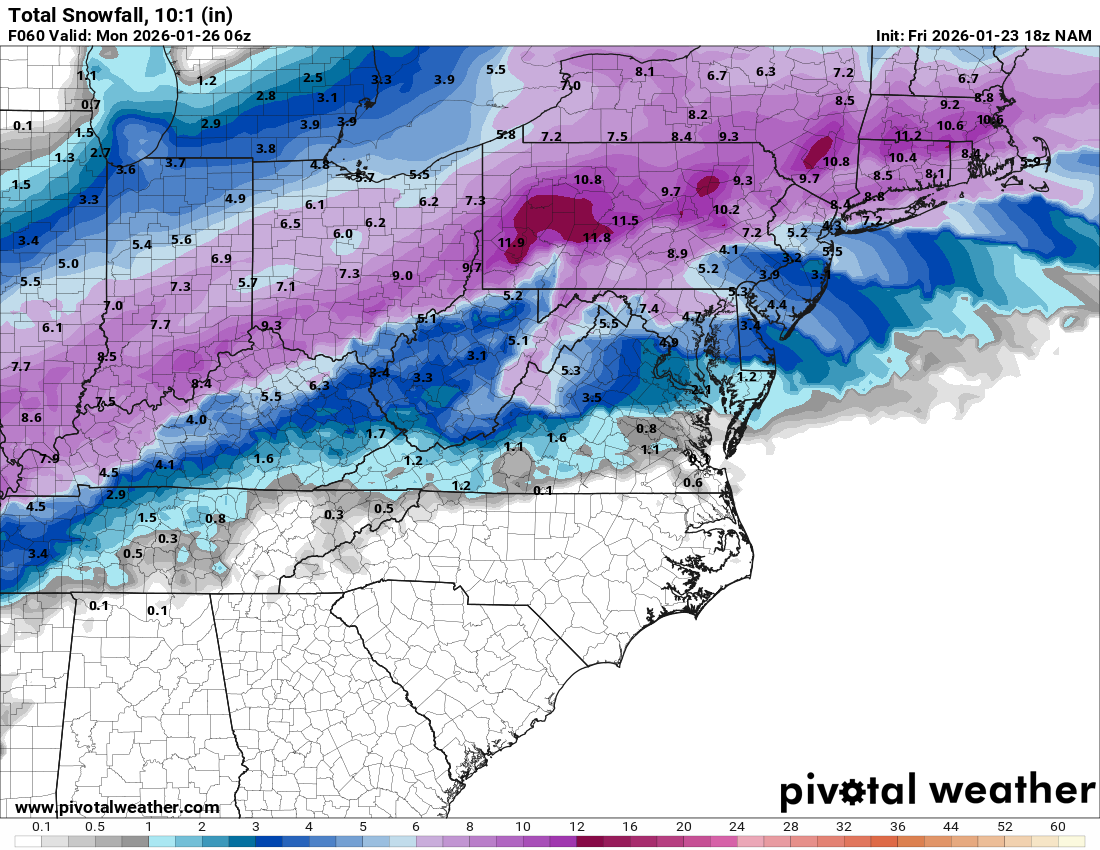
NAM has been all over the place today, probably because it is outside its useful range when the precip is falling, so its output is a bit suspect until probably 06Z tomorrow; similarly, people are looking at the 48 hr HRRR, which is just dumb - it's accuracy at 4.8 hrs sometimes sucks, but it's not build for 48 hrs. Same thing for the new NAM, the RRFS, which is showing a more snowy output, but is suspect now. At 18Z, the AIGFS. Euro-AIFS, RGEM, GFS, UK, and ICON look fairly similar to 12Z and the Euro bumped snowfall up a bit and precip, so more sleet too; all would support 8-12" for most of CNJ with ratios, which is why I still think the NWS is too high with 10-15" forecast for CNJ; although the GFS, AIFS (at 12Z) and NBM have those levels.NAM'd
Last edited:
Well looky here, lol. The NWS finally dropped their snowfall forecasts to very close to what WxRisk and Lee Goldberg have and what I've been saying they should have for areas S of 78 and especially S of 276/195. i.e., a general 8-12" of snow/sleet. The new and the previous maps are below.NAM has been all over the place today, probably because it is outside its useful range when the precip is falling, so its output is a bit suspect until probably 06Z tomorrow; similarly, people are looking at the 48 hr HRRR, which is just dumb - it's accuracy at 4.8 hrs sometimes sucks, but it's not build for 48 hrs. Same thing for the new NAM, the RRFS, which is showing a more snowy output, but is suspect now. At 18Z, the AIGFS. RGEM, GFS, UK, and ICON (and Euro at 12Z) look fairly similar to 12Z; all would support 8-12" for most of CNJ with ratios, which is why I still think the NWS is too high with 10-15" forecast for CNJ; although the GFS, AIFS (at 12Z) and NBM have those levels.


Attachments
-
 1769209008816.png460.2 KB · Views: 11
 -
 1769209035633.png201.3 KB · Views: 12
Last edited:
I hope they die on that 12" hill at Toms River.Well looky here, lol. The NWS finally dropped their snowfall forecasts to very close to what WxRisk and Lee Goldberg have and what I've been saying they should have for areas S of 78 and especially S of 276/195. i.e., a general 8-12" of snow/sleet. The new and the previous maps are below.
View attachment 1159944
View attachment 1159943
Lee Goldberg has the shore at 4-8".
They willI hope they die on that 12" hill at Toms River.
Lee Goldberg has the shore at 4-8".
This seems like a different version now. By Sunday I'm expecting some of the map to be blue 4-6" range. That ice is concerning. Just give me all snow
Seems to have gotten a lot colder and more windy the last hour or so. This must be the cold front they were talking about
I'm training for a half Marathon and have a 6 mile run scheduled for tomorrow AM that I am NOT looking forward to hahaha.Seems to have gotten a lot colder and more windy the last hour or so. This must be the cold front they were talking about
Depending on when I hit the road the feels like temperature will probably be sub 0
I haven’t done much running lately but last year I ran a few days a week throughout winter. Days like tomorrow suck for running.I'm training for a half Marathon and have a 6 mile run scheduled for tomorrow AM that I am NOT looking forward to hahaha.
Depending on when I hit the road the feels like temperature will probably be sub 0
Good luck with the half marathon and hopefully the wind won’t be too bad tomorrow. The wind was worse than the cold for me.
thats crazy .Just go to Retro and pay $10 for dayI'm training for a half Marathon and have a 6 mile run scheduled for tomorrow AM that I am NOT looking forward to hahaha.
Depending on when I hit the road the feels like temperature will probably be sub 0
Hahahaha. Running on the treadmill is the worst. You warm up very quickly when running outside. Just have to have the proper layers!thats crazy .Just go to Retro and pay $10 for day
This seems like a different version now. By Sunday I'm expecting some of the map to be blue 4-6" range. That ice is concerning. Just give me all snow
I posted that a few posts above...
4-7 am Sunday, roughly - should come in like a wall after 15-30 minutes of flurries moistening up the column...when is the snow supposed to start? don't recall seeing that so sorry if I missed it
They dropped TR to 10" around 5 pm - see the map above. If only the NAM continues to show much more sleet, then the NWS might not back off too much, but if a few other models start showing NAM-like solutions of 4-6" of snow then 2-3" of sleet (still 6-8" on the ground with a frozen mass of 10-15" of 10:1 snow, so very impactful still) then they will slowly step down accumulations. The NAM is right with sleet situations sometimes, but not always, so they're going to want agreement. Some thought it was right on 12/27, but the low amounts in NJ were more due to less precip and poor snow growth aloft, not sleet - the Euro actually nailed 12/27.I hope they die on that 12" hill at Toms River.
Lee Goldberg has the shore at 4-8".
thank you4-7 am Sunday, roughly - should come in like a wall after 15-30 minutes of flurries moistening up the column...
I don't even watch the news or check the phone, I always come here for you and bac. I truly think these weather threads, despite some of the nanny whining on occasion by some, are the best threads on this board
thank you numbers and @bac2therac
Saturday is a regular running day and at 9am it looks like 11° and feels like -3! Ugh. I’m going to do it, however.I'm training for a half Marathon and have a 6 mile run scheduled for tomorrow AM that I am NOT looking forward to hahaha.
Depending on when I hit the road the feels like temperature will probably be sub 0
I know someone (fellow RU guy, actually) who recently ran a full marathon in Antarctica. When the demons come for you, just remember you’re not doing that.I'm training for a half Marathon and have a 6 mile run scheduled for tomorrow AM that I am NOT looking forward to hahaha.
Depending on when I hit the road the feels like temperature will probably be sub 0
So it looks like 12 inches + for eastern Bergen county Sunday...with another storm set for a week from this Monday.
It's turning into my least favorite winter in many years.
BTW, it looks like we were lucky that the Giants or the Jets didn't make it this far in the NFL playoffs and had a home game this Sunday at Giants stadium.
It's turning into my least favorite winter in many years.
BTW, it looks like we were lucky that the Giants or the Jets didn't make it this far in the NFL playoffs and had a home game this Sunday at Giants stadium.
Saw that, but yours had different numbers that’s why I posted this one.I posted that a few posts above...